You are here: Home > Network List > AZ - ANZA Regional Network Stations List
> Station SHUM AZ.SHUM > Earthquake Result Viewer
SHUM AZ.SHUM - Earthquake Result Viewer
*The percent match for this event was below the threshold and hence no stack was calculated.
| Earthquake location: |
Sea Of Okhotsk |
| Earthquake latitude/longitude: |
52.3/151.5 |
| Earthquake time(UTC): |
1996/08/30 (243) 21:13:41 GMT |
| Earthquake Depth: |
580 km |
| Earthquake Magnitude: |
5.5 UNKNOWN, 5.1 MB, 5.4 MW |
| Earthquake Catalog/Contributor: |
WHDF/NEIC |
|
| Network: |
AZ ANZA Regional Network |
| Station: |
SHUM AZ.SHUM |
| Lat/Lon: |
33.63 N/116.44 W |
| Elevation: |
1195 m |
|
| Distance: |
65.4 deg |
| Az: |
66.519 deg |
| Baz: |
317.559 deg |
| Ray Param: |
$rayparam |
*The percent match for this event was below the threshold and hence was not used in the summary stack. |
|
| Radial Match: |
37.44075 % |
| Radial Bump: |
400 |
| Transverse Match: |
58.85671 % |
| Transverse Bump: |
400 |
| SOD ConfigId: |
4480 |
| Insert Time: |
2010-02-26 20:41:23.546 +0000 |
| GWidth: |
2.5 |
| Max Bumps: |
400 |
| Tol: |
0.001 |
|
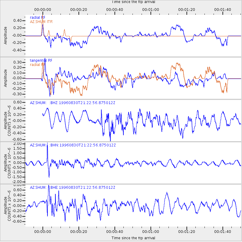
Signal To Noise
| Channel | StoN | STA | LTA |
| AZ:SHUM: :BHN:19960830T21:22:56.875012Z | 2.6264513 | 5.866553E-7 | 2.2336424E-7 |
| AZ:SHUM: :BHE:19960830T21:22:56.875012Z | 1.809767 | 4.4674553E-7 | 2.468525E-7 |
| AZ:SHUM: :BHZ:19960830T21:22:56.875012Z | 1.3829582 | 2.608826E-7 | 1.8864098E-7 |
| Arrivals |
| Ps | |
| PpPs | |
| PsPs/PpSs | |


