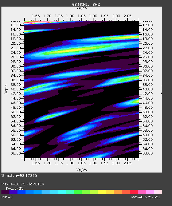
MCH1 MICHAELCHURCH, WALES - Earthquake Result Viewer

Earthquake location: Near East Coast Of Honshu, Japan
Earthquake latitude/longitude: 38.3/141.6
Earthquake time(UTC): 2011/04/07 (097) 14:32:43 GMT
Earthquake Depth: 42 km
Earthquake Magnitude: 6.9 MB, 7.0 MS, 7.1 MW, 7.1 MW
Earthquake Catalog/Contributor: WHDF/NEIC
Network: GB Great Britain Seismograph Network
Station: MCH1 MICHAELCHURCH, WALES
Lat/Lon: 52.00 N/3.00 W
Elevation: 219 m
Distance: 84.9 deg
Az: 338.92 deg
Baz: 27.249 deg
Ray Param: 0.04505992
Estimated Moho Depth: 10.75 km
Estimated Crust Vp/Vs: 1.64
Assumed Crust Vp: 6.182 km/s
Estimated Crust Vs: 3.764 km/s
Estimated Crust Poisson's Ratio: 0.21
Radial Match: 93.17875 %
Radial Bump: 400
Transverse Match: 85.05644 %
Transverse Bump: 400
SOD ConfigId: 356183
Insert Time: 2011-09-23 13:21:36.264 +0000
GWidth: 2.5
Max Bumps: 400
Tol: 0.001

Signal To Noise

ChannelStoNSTALTA
GB:MCH1: :BHZ:20110407T14:44:42.795005Z9.6386895.427623E-65.6310796E-7
GB:MCH1: :BHN:20110407T14:44:42.795005Z2.4749221.436888E-65.805791E-7
GB:MCH1: :BHE:20110407T14:44:42.795005Z1.57193379.0440227E-75.7534373E-7
Arrivals
Ps1.1 SECOND
PpPs4.5 SECOND
PsPs/PpSs5.6 SECOND