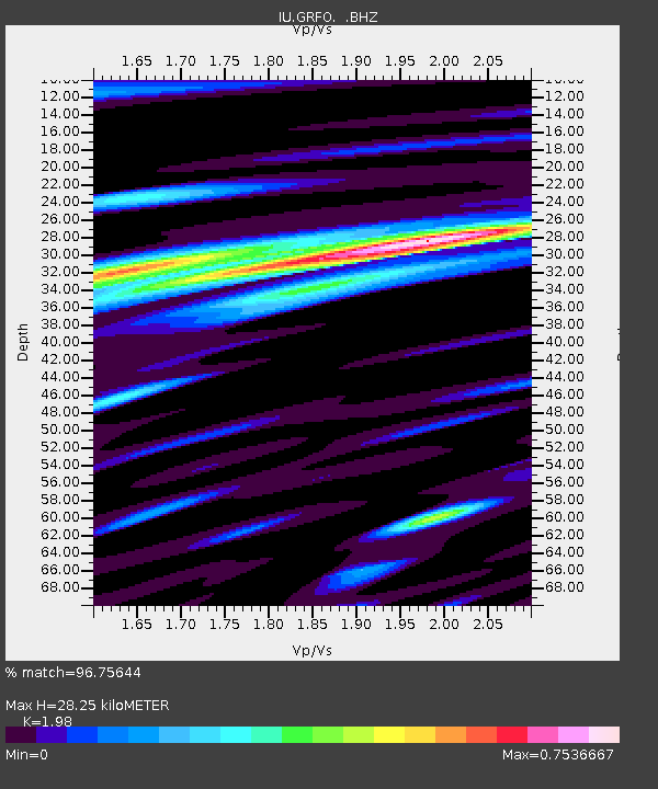
GRFO Grafenberg, Germany - Earthquake Result Viewer

Earthquake location: Near East Coast Of Honshu, Japan
Earthquake latitude/longitude: 38.3/141.6
Earthquake time(UTC): 2011/04/07 (097) 14:32:43 GMT
Earthquake Depth: 42 km
Earthquake Magnitude: 6.9 MB, 7.0 MS, 7.1 MW, 7.1 MW
Earthquake Catalog/Contributor: WHDF/NEIC
Network: IU Global Seismograph Network (GSN - IRIS/USGS)
Station: GRFO Grafenberg, Germany
Lat/Lon: 49.69 N/11.22 E
Elevation: 384 m
Distance: 82.1 deg
Az: 330.027 deg
Baz: 37.262 deg
Ray Param: 0.047078773
Estimated Moho Depth: 28.25 km
Estimated Crust Vp/Vs: 1.98
Assumed Crust Vp: 6.182 km/s
Estimated Crust Vs: 3.122 km/s
Estimated Crust Poisson's Ratio: 0.33
Radial Match: 96.75644 %
Radial Bump: 393
Transverse Match: 94.49475 %
Transverse Bump: 400
SOD ConfigId: 356183
Insert Time: 2011-09-23 13:25:24.111 +0000
GWidth: 2.5
Max Bumps: 400
Tol: 0.001

Signal To Noise

ChannelStoNSTALTA
IU:GRFO: :BHZ:20110407T14:44:28.120017Z24.8811235.407126E-62.1731843E-7
IU:GRFO: :BHN:20110407T14:44:28.120017Z7.8757541.5899561E-62.0187987E-7
IU:GRFO: :BHE:20110407T14:44:28.120017Z4.8321259.821763E-72.0325967E-7
Arrivals
Ps4.6 SECOND
PpPs13 SECOND
PsPs/PpSs18 SECOND