You are here: Home > Network List > AZ - ANZA Regional Network Stations List
> Station SHUM AZ.SHUM > Earthquake Result Viewer
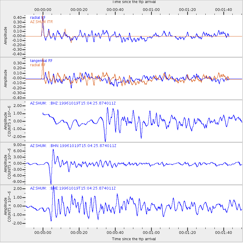
SHUM AZ.SHUM - Earthquake Result Viewer
*The percent match for this event was below the threshold and hence no stack was calculated.
| Earthquake location: |
Fiji Islands Region |
| Earthquake latitude/longitude: |
-20.4/-178.5 |
| Earthquake time(UTC): |
1996/10/19 (293) 14:53:48 GMT |
| Earthquake Depth: |
591 km |
| Earthquake Magnitude: |
6.1 MB, 6.9 UNKNOWN, 6.8 MW |
| Earthquake Catalog/Contributor: |
WHDF/NEIC |
|
| Network: |
AZ ANZA Regional Network |
| Station: |
SHUM AZ.SHUM |
| Lat/Lon: |
33.63 N/116.44 W |
| Elevation: |
1195 m |
|
| Distance: |
79.9 deg |
| Az: |
48.48 deg |
| Baz: |
237.324 deg |
| Ray Param: |
$rayparam |
*The percent match for this event was below the threshold and hence was not used in the summary stack. |
|
| Radial Match: |
67.25746 % |
| Radial Bump: |
400 |
| Transverse Match: |
67.028915 % |
| Transverse Bump: |
400 |
| SOD ConfigId: |
4480 |
| Insert Time: |
2010-02-26 20:41:36.057 +0000 |
| GWidth: |
2.5 |
| Max Bumps: |
400 |
| Tol: |
0.001 |
|
Signal To Noise
| Channel | StoN | STA | LTA |
| AZ:SHUM: :BHN:19961019T15:04:25.874011Z | 10.710437 | 3.372668E-6 | 3.1489546E-7 |
| AZ:SHUM: :BHE:19961019T15:04:25.874011Z | 3.588531 | 6.93359E-7 | 1.9321529E-7 |
| AZ:SHUM: :BHZ:19961019T15:04:25.874011Z | 1.8746936 | 9.4885866E-7 | 5.061406E-7 |
| Arrivals |
| Ps | |
| PpPs | |
| PsPs/PpSs | |


