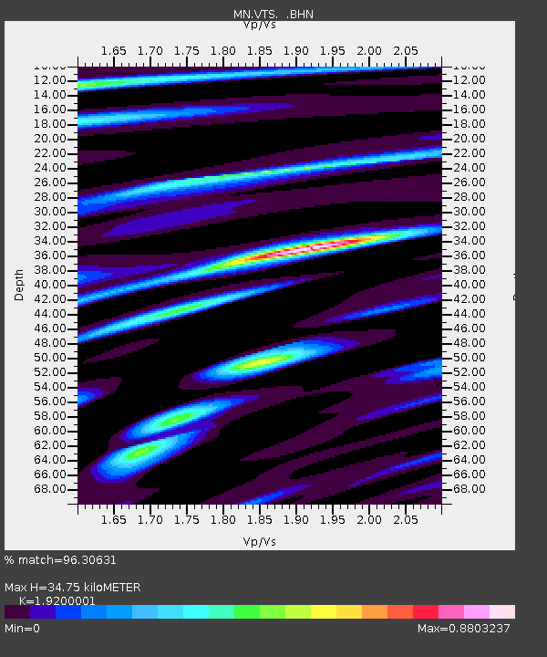
VTS Vitosha, Bulgary - Earthquake Result Viewer
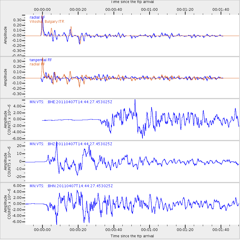
Earthquake location: Near East Coast Of Honshu, Japan
Earthquake latitude/longitude: 38.3/141.6
Earthquake time(UTC): 2011/04/07 (097) 14:32:43 GMT
Earthquake Depth: 42 km
Earthquake Magnitude: 6.9 MB, 7.0 MS, 7.1 MW, 7.1 MW
Earthquake Catalog/Contributor: WHDF/NEIC
Network: MN MEDNET Project
Station: VTS Vitosha, Bulgary
Lat/Lon: 42.62 N/23.24 E
Elevation: 1490 m
Distance: 81.9 deg
Az: 318.998 deg
Baz: 44.391 deg
Ray Param: 0.047169294
Estimated Moho Depth: 34.75 km
Estimated Crust Vp/Vs: 1.92
Assumed Crust Vp: 6.291 km/s
Estimated Crust Vs: 3.277 km/s
Estimated Crust Poisson's Ratio: 0.31
Radial Match: 96.30631 %
Radial Bump: 400
Transverse Match: 89.60041 %
Transverse Bump: 400
SOD ConfigId: 356183
Insert Time: 2011-09-23 13:32:17.859 +0000
GWidth: 2.5
Max Bumps: 400
Tol: 0.001

Signal To Noise

ChannelStoNSTALTA
MN:VTS: :BHZ:20110407T14:44:27.453025Z19.9626032.7764713E-61.3908362E-7
MN:VTS: :BHN:20110407T14:44:27.453025Z7.018796.6561853E-79.48338E-8
MN:VTS: :BHE:20110407T14:44:27.453025Z5.34865054.2855552E-78.012405E-8
Arrivals
Ps5.2 SECOND
PpPs16 SECOND
PsPs/PpSs21 SECOND