You are here: Home > Network List > GS - US Geological Survey Networks Stations List
> Station DEC12 Boyd Road Surface Site > Earthquake Result Viewer
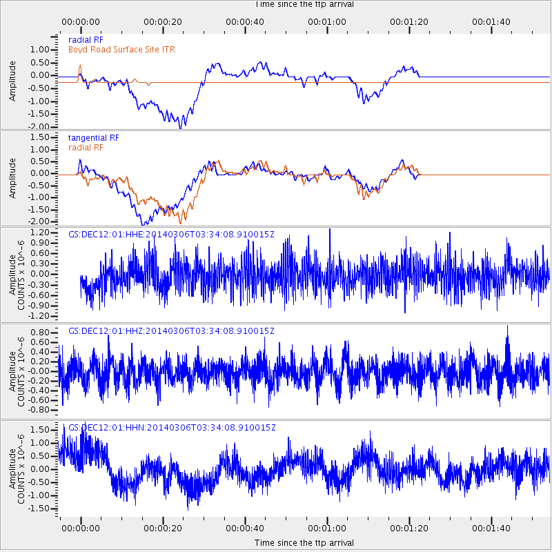
DEC12 Boyd Road Surface Site - Earthquake Result Viewer
*The percent match for this event was below the threshold and hence no stack was calculated.
| Earthquake location: |
Rat Islands, Aleutian Islands |
| Earthquake latitude/longitude: |
51.7/176.1 |
| Earthquake time(UTC): |
2014/03/06 (065) 03:24:19 GMT |
| Earthquake Depth: |
40 km |
| Earthquake Magnitude: |
5.1 MW |
| Earthquake Catalog/Contributor: |
ISC/ISC |
|
| Network: |
GS US Geological Survey Networks |
| Station: |
DEC12 Boyd Road Surface Site |
| Lat/Lon: |
39.91 N/88.91 W |
| Elevation: |
208 m |
|
| Distance: |
62.7 deg |
| Az: |
59.594 deg |
| Baz: |
315.775 deg |
| Ray Param: |
$rayparam |
*The percent match for this event was below the threshold and hence was not used in the summary stack. |
|
| Radial Match: |
50.434826 % |
| Radial Bump: |
400 |
| Transverse Match: |
51.44213 % |
| Transverse Bump: |
400 |
| SOD ConfigId: |
3390531 |
| Insert Time: |
2019-04-10 12:53:14.614 +0000 |
| GWidth: |
2.5 |
| Max Bumps: |
400 |
| Tol: |
0.001 |
|
Signal To Noise
| Channel | StoN | STA | LTA |
| GS:DEC12:01:HHZ:20140306T03:34:08.910015Z | 1.0391015 | 2.2286781E-7 | 2.1448128E-7 |
| GS:DEC12:01:HHN:20140306T03:34:08.910015Z | 1.3816578 | 9.645522E-7 | 6.981122E-7 |
| GS:DEC12:01:HHE:20140306T03:34:08.910015Z | 0.9547339 | 3.6323132E-7 | 3.8045295E-7 |
| Arrivals |
| Ps | |
| PpPs | |
| PsPs/PpSs | |


