You are here: Home > Network List > AZ - ANZA Regional Network Stations List
> Station SHUM AZ.SHUM > Earthquake Result Viewer
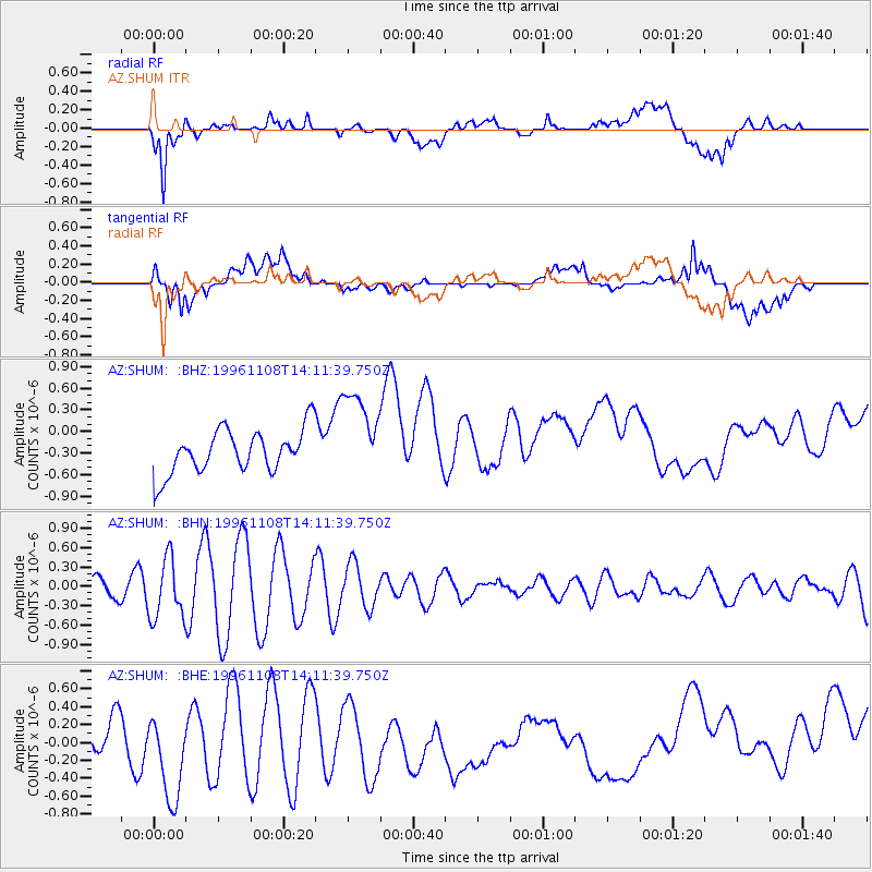
SHUM AZ.SHUM - Earthquake Result Viewer
*The percent match for this event was below the threshold and hence no stack was calculated.
| Earthquake location: |
South Of Fiji Islands |
| Earthquake latitude/longitude: |
-22.3/-179.2 |
| Earthquake time(UTC): |
1996/11/08 (313) 14:00:50 GMT |
| Earthquake Depth: |
553 km |
| Earthquake Magnitude: |
5.5 UNKNOWN, 5.2 MB |
| Earthquake Catalog/Contributor: |
WHDF/NEIC |
|
| Network: |
AZ ANZA Regional Network |
| Station: |
SHUM AZ.SHUM |
| Lat/Lon: |
33.63 N/116.44 W |
| Elevation: |
1195 m |
|
| Distance: |
81.6 deg |
| Az: |
48.585 deg |
| Baz: |
236.376 deg |
| Ray Param: |
$rayparam |
*The percent match for this event was below the threshold and hence was not used in the summary stack. |
|
| Radial Match: |
37.57262 % |
| Radial Bump: |
400 |
| Transverse Match: |
45.263245 % |
| Transverse Bump: |
400 |
| SOD ConfigId: |
4480 |
| Insert Time: |
2010-02-26 20:41:38.510 +0000 |
| GWidth: |
2.5 |
| Max Bumps: |
400 |
| Tol: |
0.001 |
|
Signal To Noise
| Channel | StoN | STA | LTA |
| AZ:SHUM: :BHN:19961108T14:11:39.750Z | 2.7726524 | 4.659656E-7 | 1.6805771E-7 |
| AZ:SHUM: :BHE:19961108T14:11:39.750Z | 3.5179055 | 5.62215E-7 | 1.5981527E-7 |
| AZ:SHUM: :BHZ:19961108T14:11:39.750Z | 2.0933242 | 6.30299E-7 | 3.0109953E-7 |
| Arrivals |
| Ps | |
| PpPs | |
| PsPs/PpSs | |


