You are here: Home > Network List > AZ - ANZA Regional Network Stations List
> Station SHUM AZ.SHUM > Earthquake Result Viewer
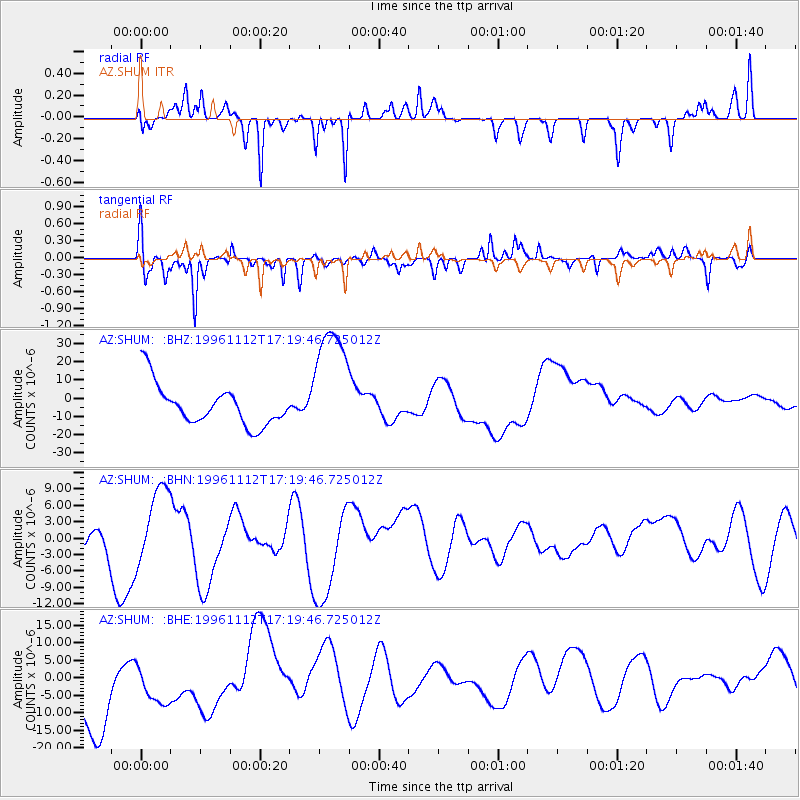
SHUM AZ.SHUM - Earthquake Result Viewer
*The percent match for this event was below the threshold and hence no stack was calculated.
| Earthquake location: |
Near Coast Of Peru |
| Earthquake latitude/longitude: |
-14.9/-75.6 |
| Earthquake time(UTC): |
1996/11/12 (317) 17:10:00 GMT |
| Earthquake Depth: |
33 km |
| Earthquake Magnitude: |
5.6 MB |
| Earthquake Catalog/Contributor: |
WHDF/NEIC |
|
| Network: |
AZ ANZA Regional Network |
| Station: |
SHUM AZ.SHUM |
| Lat/Lon: |
33.63 N/116.44 W |
| Elevation: |
1195 m |
|
| Distance: |
62.0 deg |
| Az: |
321.852 deg |
| Baz: |
134.302 deg |
| Ray Param: |
$rayparam |
*The percent match for this event was below the threshold and hence was not used in the summary stack. |
|
| Radial Match: |
38.56133 % |
| Radial Bump: |
192 |
| Transverse Match: |
66.33197 % |
| Transverse Bump: |
355 |
| SOD ConfigId: |
4480 |
| Insert Time: |
2010-02-26 20:41:40.024 +0000 |
| GWidth: |
2.5 |
| Max Bumps: |
400 |
| Tol: |
0.001 |
|
Signal To Noise
| Channel | StoN | STA | LTA |
| AZ:SHUM: :BHN:19961112T17:19:46.725012Z | 1.3118497 | 6.6172247E-6 | 5.044194E-6 |
| AZ:SHUM: :BHE:19961112T17:19:46.725012Z | 0.604419 | 7.3078704E-6 | 1.2090736E-5 |
| AZ:SHUM: :BHZ:19961112T17:19:46.725012Z | 3.0583186 | 3.398031E-5 | 1.1110781E-5 |
| Arrivals |
| Ps | |
| PpPs | |
| PsPs/PpSs | |


