You are here: Home > Network List > US - United States National Seismic Network Stations List
> Station WRAK Wrangell Island, Southeastern Alaska, Alaska, USA > Earthquake Result Viewer
WRAK Wrangell Island, Southeastern Alaska, Alaska, USA - Earthquake Result Viewer
| Earthquake location: |
Near East Coast Of Honshu, Japan |
| Earthquake latitude/longitude: |
38.3/141.6 |
| Earthquake time(UTC): |
2011/04/07 (097) 14:32:43 GMT |
| Earthquake Depth: |
42 km |
| Earthquake Magnitude: |
6.9 MB, 7.0 MS, 7.1 MW, 7.1 MW |
| Earthquake Catalog/Contributor: |
WHDF/NEIC |
|
| Network: |
US United States National Seismic Network |
| Station: |
WRAK Wrangell Island, Southeastern Alaska, Alaska, USA |
| Lat/Lon: |
56.42 N/132.35 W |
| Elevation: |
81 m |
|
| Distance: |
57.1 deg |
| Az: |
41.31 deg |
| Baz: |
290.776 deg |
| Ray Param: |
0.063606806 |
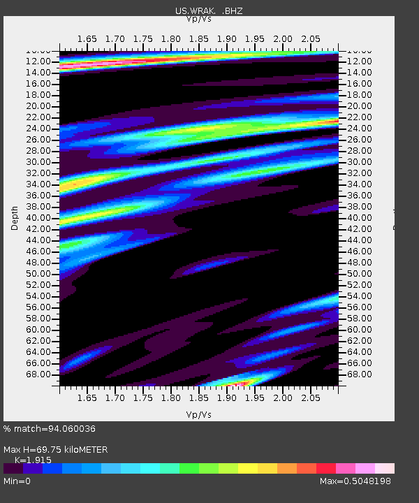
| Estimated Moho Depth: |
69.75 km |
| Estimated Crust Vp/Vs: |
1.91 |
| Assumed Crust Vp: |
6.597 km/s |
| Estimated Crust Vs: |
3.445 km/s |
| Estimated Crust Poisson's Ratio: |
0.31 |
|
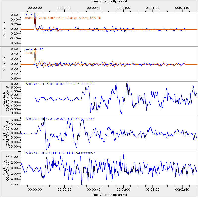
| Radial Match: |
94.060036 % |
| Radial Bump: |
400 |
| Transverse Match: |
74.418465 % |
| Transverse Bump: |
400 |
| SOD ConfigId: |
356183 |
| Insert Time: |
2011-09-23 14:00:20.387 +0000 |
| GWidth: |
2.5 |
| Max Bumps: |
400 |
| Tol: |
0.001 |
|
Signal To Noise
| Channel | StoN | STA | LTA |
| US:WRAK: :BHZ:20110407T14:41:54.899985Z | 7.2323995 | 5.3469234E-6 | 7.393015E-7 |
| US:WRAK: :BHN:20110407T14:41:54.899985Z | 1.5255994 | 1.098954E-6 | 7.203425E-7 |
| US:WRAK: :BHE:20110407T14:41:54.899985Z | 3.9506712 | 2.9396292E-6 | 7.440835E-7 |
| Arrivals |
| Ps | 10 SECOND |
| PpPs | 29 SECOND |
| PsPs/PpSs | 40 SECOND |


