You are here: Home > Network List > AZ - ANZA Regional Network Stations List
> Station SHUM AZ.SHUM > Earthquake Result Viewer
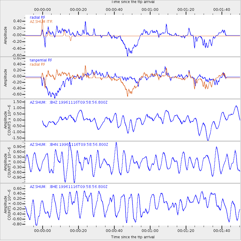
SHUM AZ.SHUM - Earthquake Result Viewer
*The percent match for this event was below the threshold and hence no stack was calculated.
| Earthquake location: |
Fiji Islands Region |
| Earthquake latitude/longitude: |
-15.1/-176.3 |
| Earthquake time(UTC): |
1996/11/16 (321) 09:47:50 GMT |
| Earthquake Depth: |
33 km |
| Earthquake Magnitude: |
5.3 MB, 5.7 MS, 6.0 UNKNOWN, 5.9 MW |
| Earthquake Catalog/Contributor: |
WHDF/NEIC |
|
| Network: |
AZ ANZA Regional Network |
| Station: |
SHUM AZ.SHUM |
| Lat/Lon: |
33.63 N/116.44 W |
| Elevation: |
1195 m |
|
| Distance: |
74.8 deg |
| Az: |
48.382 deg |
| Baz: |
239.94 deg |
| Ray Param: |
$rayparam |
*The percent match for this event was below the threshold and hence was not used in the summary stack. |
|
| Radial Match: |
47.384674 % |
| Radial Bump: |
400 |
| Transverse Match: |
45.228615 % |
| Transverse Bump: |
400 |
| SOD ConfigId: |
4480 |
| Insert Time: |
2010-02-26 20:41:43.736 +0000 |
| GWidth: |
2.5 |
| Max Bumps: |
400 |
| Tol: |
0.001 |
|
Signal To Noise
| Channel | StoN | STA | LTA |
| AZ:SHUM: :BHN:19961116T09:58:56.800Z | 1.342096 | 3.7461825E-7 | 2.7912927E-7 |
| AZ:SHUM: :BHE:19961116T09:58:56.800Z | 1.1898488 | 6.4363405E-7 | 5.409377E-7 |
| AZ:SHUM: :BHZ:19961116T09:58:56.800Z | 1.5377332 | 5.003135E-7 | 3.253578E-7 |
| Arrivals |
| Ps | |
| PpPs | |
| PsPs/PpSs | |


