You are here: Home > Network List > CI - Caltech Regional Seismic Network Stations List
> Station LRL Laurel Mtn Radio Fac, Ridgecrest, CA, USA > Earthquake Result Viewer
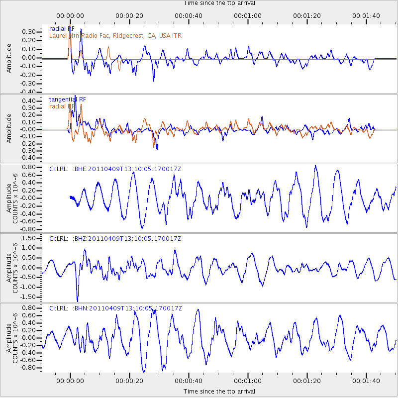
LRL Laurel Mtn Radio Fac, Ridgecrest, CA, USA - Earthquake Result Viewer
*The percent match for this event was below the threshold and hence no stack was calculated.
| Earthquake location: |
Kyushu, Japan |
| Earthquake latitude/longitude: |
30.0/131.8 |
| Earthquake time(UTC): |
2011/04/09 (099) 12:57:48 GMT |
| Earthquake Depth: |
17 km |
| Earthquake Magnitude: |
6.1 MB, 5.6 MS, 6.0 MW, 6.0 MW |
| Earthquake Catalog/Contributor: |
WHDF/NEIC |
|
| Network: |
CI Caltech Regional Seismic Network |
| Station: |
LRL Laurel Mtn Radio Fac, Ridgecrest, CA, USA |
| Lat/Lon: |
35.48 N/117.68 W |
| Elevation: |
1340 m |
|
| Distance: |
87.8 deg |
| Az: |
49.897 deg |
| Baz: |
305.614 deg |
| Ray Param: |
$rayparam |
*The percent match for this event was below the threshold and hence was not used in the summary stack. |
|
| Radial Match: |
51.789463 % |
| Radial Bump: |
354 |
| Transverse Match: |
50.45734 % |
| Transverse Bump: |
400 |
| SOD ConfigId: |
356183 |
| Insert Time: |
2011-09-27 02:41:55.733 +0000 |
| GWidth: |
2.5 |
| Max Bumps: |
400 |
| Tol: |
0.001 |
|
Signal To Noise
| Channel | StoN | STA | LTA |
| CI:LRL: :BHZ:20110409T13:10:05.170017Z | 3.3323953 | 6.056695E-7 | 1.81752E-7 |
| CI:LRL: :BHN:20110409T13:10:05.170017Z | 1.0789918 | 2.1131069E-7 | 1.9584087E-7 |
| CI:LRL: :BHE:20110409T13:10:05.170017Z | 0.92148834 | 3.0153194E-7 | 3.2722275E-7 |
| Arrivals |
| Ps | |
| PpPs | |
| PsPs/PpSs | |


