You are here: Home > Network List > TA - USArray Transportable Network (new EarthScope stations) Stations List
> Station MSTX Muleshoe, TX, USA > Earthquake Result Viewer
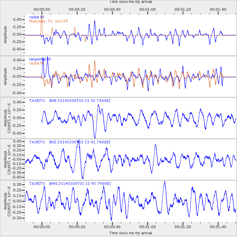
MSTX Muleshoe, TX, USA - Earthquake Result Viewer
*The percent match for this event was below the threshold and hence no stack was calculated.
| Earthquake location: |
Rat Islands, Aleutian Islands |
| Earthquake latitude/longitude: |
51.7/176.1 |
| Earthquake time(UTC): |
2014/03/06 (065) 03:24:19 GMT |
| Earthquake Depth: |
40 km |
| Earthquake Magnitude: |
5.1 MW |
| Earthquake Catalog/Contributor: |
ISC/ISC |
|
| Network: |
TA USArray Transportable Network (new EarthScope stations) |
| Station: |
MSTX Muleshoe, TX, USA |
| Lat/Lon: |
33.97 N/102.77 W |
| Elevation: |
1167 m |
|
| Distance: |
59.0 deg |
| Az: |
73.361 deg |
| Baz: |
314.179 deg |
| Ray Param: |
$rayparam |
*The percent match for this event was below the threshold and hence was not used in the summary stack. |
|
| Radial Match: |
49.8901 % |
| Radial Bump: |
400 |
| Transverse Match: |
57.936546 % |
| Transverse Bump: |
400 |
| SOD ConfigId: |
3390531 |
| Insert Time: |
2019-04-10 12:56:34.301 +0000 |
| GWidth: |
2.5 |
| Max Bumps: |
400 |
| Tol: |
0.001 |
|
Signal To Noise
| Channel | StoN | STA | LTA |
| TA:MSTX: :BHZ:20140306T03:33:43.74998Z | 0.85496366 | 1.0730826E-7 | 1.2551207E-7 |
| TA:MSTX: :BHN:20140306T03:33:43.74998Z | 0.86654645 | 1.2998709E-7 | 1.5000592E-7 |
| TA:MSTX: :BHE:20140306T03:33:43.74998Z | 3.0989587 | 2.8509083E-7 | 9.199568E-8 |
| Arrivals |
| Ps | |
| PpPs | |
| PsPs/PpSs | |


