You are here: Home > Network List > AZ - ANZA Regional Network Stations List
> Station SHUM AZ.SHUM > Earthquake Result Viewer
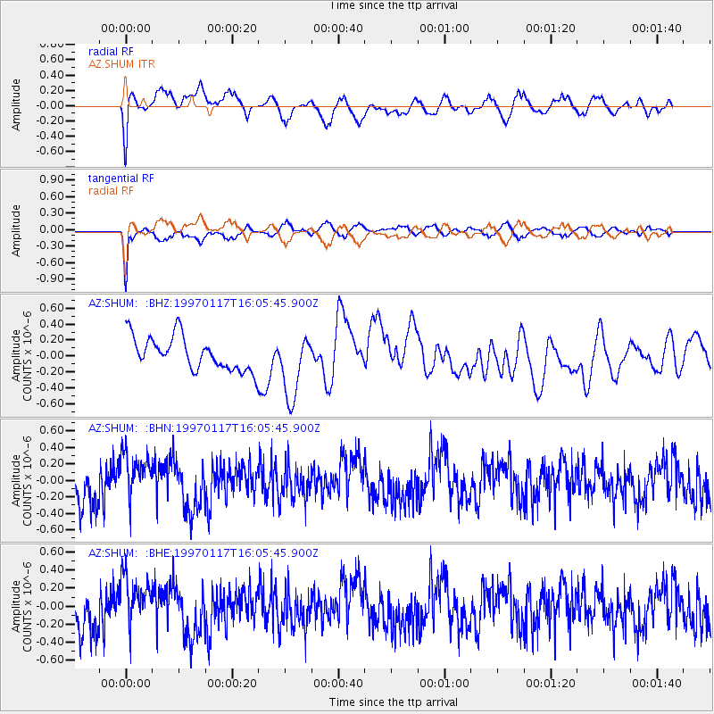
SHUM AZ.SHUM - Earthquake Result Viewer
*The percent match for this event was below the threshold and hence no stack was calculated.
| Earthquake location: |
Ryukyu Islands, Japan |
| Earthquake latitude/longitude: |
28.8/130.0 |
| Earthquake time(UTC): |
1997/01/17 (017) 15:53:13 GMT |
| Earthquake Depth: |
33 km |
| Earthquake Magnitude: |
5.9 MB, 6.3 MS, 6.3 UNKNOWN, 6.2 MW |
| Earthquake Catalog/Contributor: |
WHDF/NEIC |
|
| Network: |
AZ ANZA Regional Network |
| Station: |
SHUM AZ.SHUM |
| Lat/Lon: |
33.63 N/116.44 W |
| Elevation: |
1195 m |
|
| Distance: |
91.7 deg |
| Az: |
49.893 deg |
| Baz: |
306.441 deg |
| Ray Param: |
$rayparam |
*The percent match for this event was below the threshold and hence was not used in the summary stack. |
|
| Radial Match: |
61.91663 % |
| Radial Bump: |
360 |
| Transverse Match: |
75.572266 % |
| Transverse Bump: |
318 |
| SOD ConfigId: |
4480 |
| Insert Time: |
2010-02-26 20:41:57.767 +0000 |
| GWidth: |
2.5 |
| Max Bumps: |
400 |
| Tol: |
0.001 |
|
Signal To Noise
| Channel | StoN | STA | LTA |
| AZ:SHUM: :BHN:19970117T16:05:45.900Z | 1.3013768 | 3.107935E-7 | 2.3881898E-7 |
| AZ:SHUM: :BHE:19970117T16:05:45.900Z | 1.2846669 | 3.0598198E-7 | 2.3818002E-7 |
| AZ:SHUM: :BHZ:19970117T16:05:45.900Z | 1.9315956 | 4.0497235E-7 | 2.0965692E-7 |
| Arrivals |
| Ps | |
| PpPs | |
| PsPs/PpSs | |


