You are here: Home > Network List > IW - Intermountain West Stations List
> Station MOOW Moose Ponds, Wyoming, USA > Earthquake Result Viewer
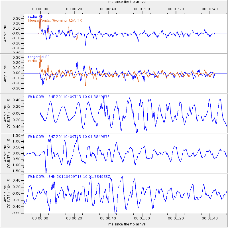
MOOW Moose Ponds, Wyoming, USA - Earthquake Result Viewer
*The percent match for this event was below the threshold and hence no stack was calculated.
| Earthquake location: |
Kyushu, Japan |
| Earthquake latitude/longitude: |
30.0/131.8 |
| Earthquake time(UTC): |
2011/04/09 (099) 12:57:48 GMT |
| Earthquake Depth: |
17 km |
| Earthquake Magnitude: |
6.1 MB, 5.6 MS, 6.0 MW, 6.0 MW |
| Earthquake Catalog/Contributor: |
WHDF/NEIC |
|
| Network: |
IW Intermountain West |
| Station: |
MOOW Moose Ponds, Wyoming, USA |
| Lat/Lon: |
43.75 N/110.74 W |
| Elevation: |
2128 m |
|
| Distance: |
87.0 deg |
| Az: |
40.081 deg |
| Baz: |
309.582 deg |
| Ray Param: |
$rayparam |
*The percent match for this event was below the threshold and hence was not used in the summary stack. |
|
| Radial Match: |
67.95542 % |
| Radial Bump: |
400 |
| Transverse Match: |
70.3297 % |
| Transverse Bump: |
400 |
| SOD ConfigId: |
356183 |
| Insert Time: |
2011-09-27 02:53:11.996 +0000 |
| GWidth: |
2.5 |
| Max Bumps: |
400 |
| Tol: |
0.001 |
|
Signal To Noise
| Channel | StoN | STA | LTA |
| IW:MOOW: :BHZ:20110409T13:10:01.384983Z | 3.2593346 | 6.367693E-7 | 1.9536789E-7 |
| IW:MOOW: :BHN:20110409T13:10:01.384983Z | 1.0421308 | 1.2780653E-7 | 1.2263962E-7 |
| IW:MOOW: :BHE:20110409T13:10:01.384983Z | 1.1478939 | 2.103268E-7 | 1.8322844E-7 |
| Arrivals |
| Ps | |
| PpPs | |
| PsPs/PpSs | |


