You are here: Home > Network List > AZ - ANZA Regional Network Stations List
> Station SHUM AZ.SHUM > Earthquake Result Viewer
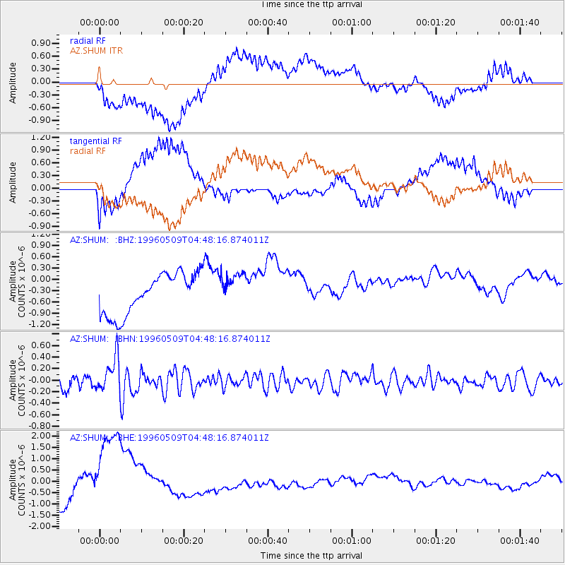
SHUM AZ.SHUM - Earthquake Result Viewer
*The percent match for this event was below the threshold and hence no stack was calculated.
| Earthquake location: |
South Of Kermadec Islands |
| Earthquake latitude/longitude: |
-32.6/-179.4 |
| Earthquake time(UTC): |
1996/05/09 (130) 04:36:03 GMT |
| Earthquake Depth: |
77 km |
| Earthquake Magnitude: |
5.8 UNKNOWN, 5.0 MS, 5.4 MB |
| Earthquake Catalog/Contributor: |
WHDF/NEIC |
|
| Network: |
AZ ANZA Regional Network |
| Station: |
SHUM AZ.SHUM |
| Lat/Lon: |
33.63 N/116.44 W |
| Elevation: |
1195 m |
|
| Distance: |
88.6 deg |
| Az: |
48.005 deg |
| Baz: |
228.748 deg |
| Ray Param: |
$rayparam |
*The percent match for this event was below the threshold and hence was not used in the summary stack. |
|
| Radial Match: |
31.809586 % |
| Radial Bump: |
400 |
| Transverse Match: |
48.692142 % |
| Transverse Bump: |
400 |
| SOD ConfigId: |
4480 |
| Insert Time: |
2010-02-26 20:42:07.774 +0000 |
| GWidth: |
2.5 |
| Max Bumps: |
400 |
| Tol: |
0.001 |
|
Signal To Noise
| Channel | StoN | STA | LTA |
| AZ:SHUM: :BHN:19960509T04:48:16.874011Z | 2.42694 | 3.00752E-7 | 1.2392229E-7 |
| AZ:SHUM: :BHE:19960509T04:48:16.874011Z | 4.338467 | 2.299627E-6 | 5.300552E-7 |
| AZ:SHUM: :BHZ:19960509T04:48:16.874011Z | 0.78049475 | 4.2152288E-7 | 5.400714E-7 |
| Arrivals |
| Ps | |
| PpPs | |
| PsPs/PpSs | |


