You are here: Home > Network List > AZ - ANZA Regional Network Stations List
> Station SHUM AZ.SHUM > Earthquake Result Viewer
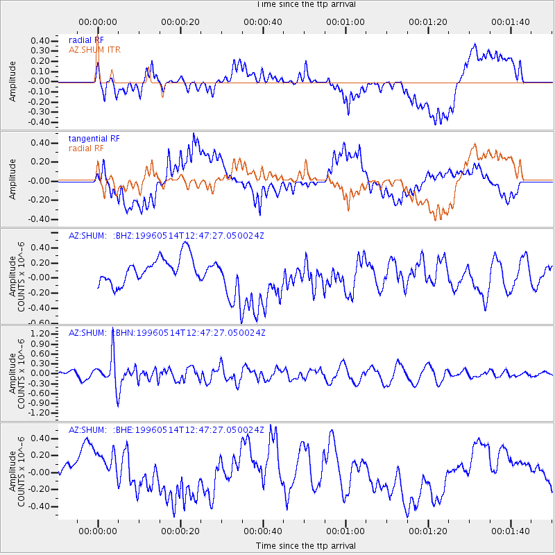
SHUM AZ.SHUM - Earthquake Result Viewer
*The percent match for this event was below the threshold and hence no stack was calculated.
| Earthquake location: |
Fiji Islands Region |
| Earthquake latitude/longitude: |
-18.0/-178.5 |
| Earthquake time(UTC): |
1996/05/14 (135) 12:36:59 GMT |
| Earthquake Depth: |
605 km |
| Earthquake Magnitude: |
5.5 MB, 5.6 UNKNOWN |
| Earthquake Catalog/Contributor: |
WHDF/NEIC |
|
| Network: |
AZ ANZA Regional Network |
| Station: |
SHUM AZ.SHUM |
| Lat/Lon: |
33.63 N/116.44 W |
| Elevation: |
1195 m |
|
| Distance: |
78.3 deg |
| Az: |
48.849 deg |
| Baz: |
239.216 deg |
| Ray Param: |
$rayparam |
*The percent match for this event was below the threshold and hence was not used in the summary stack. |
|
| Radial Match: |
49.38095 % |
| Radial Bump: |
400 |
| Transverse Match: |
40.11845 % |
| Transverse Bump: |
400 |
| SOD ConfigId: |
4480 |
| Insert Time: |
2010-02-26 20:42:09.919 +0000 |
| GWidth: |
2.5 |
| Max Bumps: |
400 |
| Tol: |
0.001 |
|
Signal To Noise
| Channel | StoN | STA | LTA |
| AZ:SHUM: :BHN:19960514T12:47:27.050024Z | 5.970912 | 4.8192845E-7 | 8.07127E-8 |
| AZ:SHUM: :BHE:19960514T12:47:27.050024Z | 0.5901446 | 1.6841304E-7 | 2.8537588E-7 |
| AZ:SHUM: :BHZ:19960514T12:47:27.050024Z | 2.0633535 | 3.4306376E-7 | 1.6626514E-7 |
| Arrivals |
| Ps | |
| PpPs | |
| PsPs/PpSs | |


