You are here: Home > Network List > AZ - ANZA Regional Network Stations List
> Station SHUM AZ.SHUM > Earthquake Result Viewer
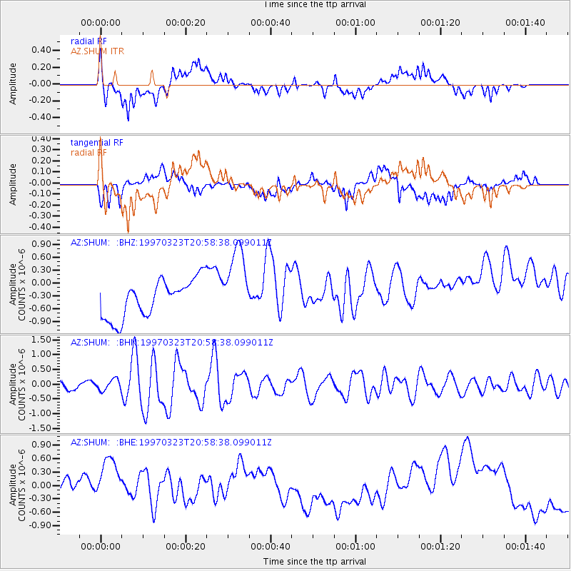
SHUM AZ.SHUM - Earthquake Result Viewer
*The percent match for this event was below the threshold and hence no stack was calculated.
| Earthquake location: |
Northern Mid-Atlantic Ridge |
| Earthquake latitude/longitude: |
31.0/-41.5 |
| Earthquake time(UTC): |
1997/03/23 (082) 20:48:48 GMT |
| Earthquake Depth: |
10 km |
| Earthquake Magnitude: |
5.9 MS, 5.4 MB, 5.9 UNKNOWN, 5.9 MW |
| Earthquake Catalog/Contributor: |
WHDF/NEIC |
|
| Network: |
AZ ANZA Regional Network |
| Station: |
SHUM AZ.SHUM |
| Lat/Lon: |
33.63 N/116.44 W |
| Elevation: |
1195 m |
|
| Distance: |
62.0 deg |
| Az: |
294.208 deg |
| Baz: |
69.862 deg |
| Ray Param: |
$rayparam |
*The percent match for this event was below the threshold and hence was not used in the summary stack. |
|
| Radial Match: |
38.21683 % |
| Radial Bump: |
400 |
| Transverse Match: |
20.103601 % |
| Transverse Bump: |
400 |
| SOD ConfigId: |
4480 |
| Insert Time: |
2010-02-26 20:42:13.747 +0000 |
| GWidth: |
2.5 |
| Max Bumps: |
400 |
| Tol: |
0.001 |
|
Signal To Noise
| Channel | StoN | STA | LTA |
| AZ:SHUM: :BHN:19970323T20:58:38.099011Z | 1.062886 | 1.9093224E-7 | 1.7963568E-7 |
| AZ:SHUM: :BHE:19970323T20:58:38.099011Z | 1.1324147 | 4.8380684E-7 | 4.2723468E-7 |
| AZ:SHUM: :BHZ:19970323T20:58:38.099011Z | 1.9973524 | 8.8081134E-7 | 4.4098948E-7 |
| Arrivals |
| Ps | |
| PpPs | |
| PsPs/PpSs | |


