You are here: Home > Network List > AZ - ANZA Regional Network Stations List
> Station SHUM AZ.SHUM > Earthquake Result Viewer
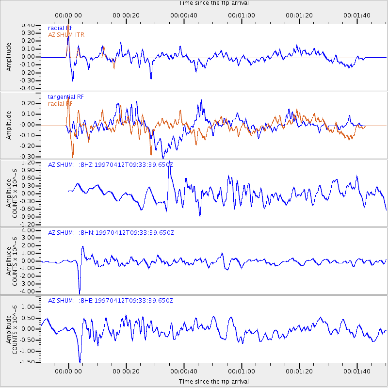
SHUM AZ.SHUM - Earthquake Result Viewer
*The percent match for this event was below the threshold and hence no stack was calculated.
| Earthquake location: |
Kermadec Islands Region |
| Earthquake latitude/longitude: |
-28.2/-178.4 |
| Earthquake time(UTC): |
1997/04/12 (102) 09:21:56 GMT |
| Earthquake Depth: |
184 km |
| Earthquake Magnitude: |
5.8 MB, 6.0 UNKNOWN, 6.0 MW |
| Earthquake Catalog/Contributor: |
WHDF/NEIC |
|
| Network: |
AZ ANZA Regional Network |
| Station: |
SHUM AZ.SHUM |
| Lat/Lon: |
33.63 N/116.44 W |
| Elevation: |
1195 m |
|
| Distance: |
85.0 deg |
| Az: |
47.645 deg |
| Baz: |
231.443 deg |
| Ray Param: |
$rayparam |
*The percent match for this event was below the threshold and hence was not used in the summary stack. |
|
| Radial Match: |
63.987335 % |
| Radial Bump: |
400 |
| Transverse Match: |
42.113827 % |
| Transverse Bump: |
400 |
| SOD ConfigId: |
4480 |
| Insert Time: |
2010-02-26 20:42:21.623 +0000 |
| GWidth: |
2.5 |
| Max Bumps: |
400 |
| Tol: |
0.001 |
|
Signal To Noise
| Channel | StoN | STA | LTA |
| AZ:SHUM: :BHN:19970412T09:33:39.650Z | 5.9063644 | 1.3206809E-6 | 2.2360301E-7 |
| AZ:SHUM: :BHE:19970412T09:33:39.650Z | 1.8285002 | 5.396508E-7 | 2.9513302E-7 |
| AZ:SHUM: :BHZ:19970412T09:33:39.650Z | 2.1244454 | 4.2092867E-7 | 1.9813578E-7 |
| Arrivals |
| Ps | |
| PpPs | |
| PsPs/PpSs | |


