You are here: Home > Network List > AZ - ANZA Regional Network Stations List
> Station SHUM AZ.SHUM > Earthquake Result Viewer
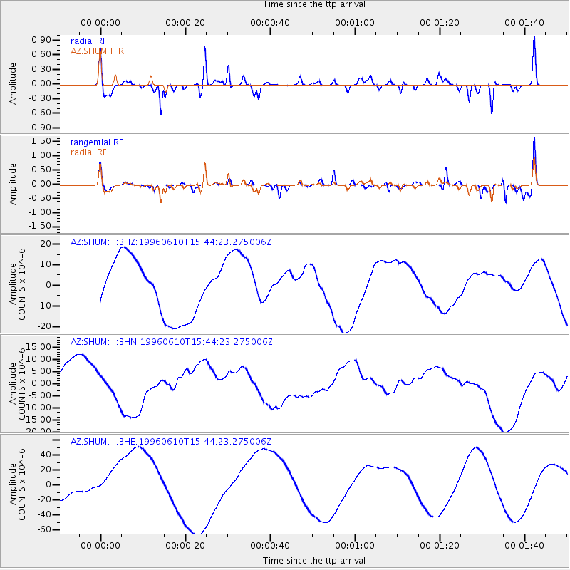
SHUM AZ.SHUM - Earthquake Result Viewer
*The percent match for this event was below the threshold and hence no stack was calculated.
| Earthquake location: |
Andreanof Islands, Aleutian Is. |
| Earthquake latitude/longitude: |
51.2/-176.8 |
| Earthquake time(UTC): |
1996/06/10 (162) 15:36:29 GMT |
| Earthquake Depth: |
33 km |
| Earthquake Magnitude: |
5.5 MB |
| Earthquake Catalog/Contributor: |
WHDF/NEIC |
|
| Network: |
AZ ANZA Regional Network |
| Station: |
SHUM AZ.SHUM |
| Lat/Lon: |
33.63 N/116.44 W |
| Elevation: |
1195 m |
|
| Distance: |
46.5 deg |
| Az: |
87.949 deg |
| Baz: |
311.064 deg |
| Ray Param: |
$rayparam |
*The percent match for this event was below the threshold and hence was not used in the summary stack. |
|
| Radial Match: |
64.12051 % |
| Radial Bump: |
335 |
| Transverse Match: |
42.547638 % |
| Transverse Bump: |
293 |
| SOD ConfigId: |
4480 |
| Insert Time: |
2010-02-26 20:42:24.016 +0000 |
| GWidth: |
2.5 |
| Max Bumps: |
400 |
| Tol: |
0.001 |
|
Signal To Noise
| Channel | StoN | STA | LTA |
| AZ:SHUM: :BHN:19960610T15:44:23.275006Z | 0.443139 | 5.8833484E-6 | 1.3276532E-5 |
| AZ:SHUM: :BHE:19960610T15:44:23.275006Z | 2.3927522 | 2.4327439E-5 | 1.0167138E-5 |
| AZ:SHUM: :BHZ:19960610T15:44:23.275006Z | 1.3095646 | 1.7895527E-5 | 1.366525E-5 |
| Arrivals |
| Ps | |
| PpPs | |
| PsPs/PpSs | |


