You are here: Home > Network List > AZ - ANZA Regional Network Stations List
> Station SHUM AZ.SHUM > Earthquake Result Viewer
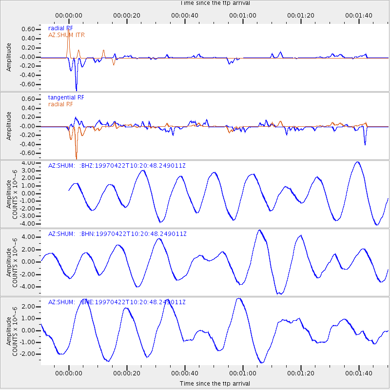
SHUM AZ.SHUM - Earthquake Result Viewer
*The percent match for this event was below the threshold and hence no stack was calculated.
| Earthquake location: |
Windward Islands |
| Earthquake latitude/longitude: |
11.0/-61.0 |
| Earthquake time(UTC): |
1997/04/22 (112) 10:11:44 GMT |
| Earthquake Depth: |
5.0 km |
| Earthquake Magnitude: |
5.6 MB |
| Earthquake Catalog/Contributor: |
WHDF/NEIC |
|
| Network: |
AZ ANZA Regional Network |
| Station: |
SHUM AZ.SHUM |
| Lat/Lon: |
33.63 N/116.44 W |
| Elevation: |
1195 m |
|
| Distance: |
55.3 deg |
| Az: |
303.288 deg |
| Baz: |
100.373 deg |
| Ray Param: |
$rayparam |
*The percent match for this event was below the threshold and hence was not used in the summary stack. |
|
| Radial Match: |
79.992584 % |
| Radial Bump: |
285 |
| Transverse Match: |
56.000626 % |
| Transverse Bump: |
400 |
| SOD ConfigId: |
4480 |
| Insert Time: |
2010-02-26 20:42:26.734 +0000 |
| GWidth: |
2.5 |
| Max Bumps: |
400 |
| Tol: |
0.001 |
|
Signal To Noise
| Channel | StoN | STA | LTA |
| AZ:SHUM: :BHN:19970422T10:20:48.249011Z | 2.217189 | 1.857515E-6 | 8.377793E-7 |
| AZ:SHUM: :BHE:19970422T10:20:48.249011Z | 2.4530694 | 1.6322688E-6 | 6.653985E-7 |
| AZ:SHUM: :BHZ:19970422T10:20:48.249011Z | 2.0203602 | 2.667269E-6 | 1.3201948E-6 |
| Arrivals |
| Ps | |
| PpPs | |
| PsPs/PpSs | |


