You are here: Home > Network List > TA - USArray Transportable Network (new EarthScope stations) Stations List
> Station L02D Cave Junction, OR, USA > Earthquake Result Viewer
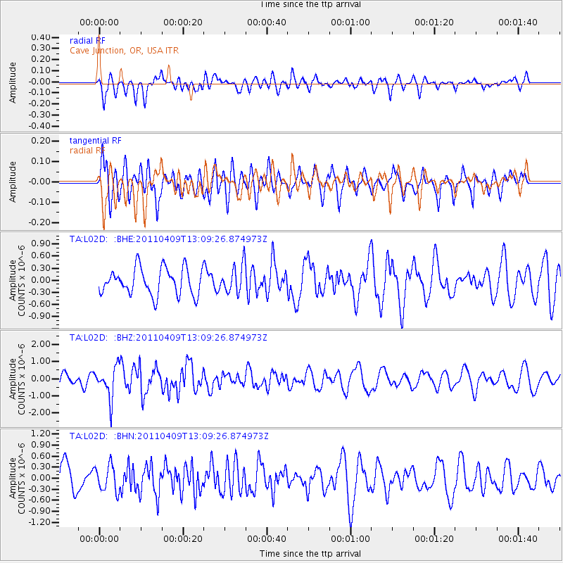
L02D Cave Junction, OR, USA - Earthquake Result Viewer
*The percent match for this event was below the threshold and hence no stack was calculated.
| Earthquake location: |
Kyushu, Japan |
| Earthquake latitude/longitude: |
30.0/131.8 |
| Earthquake time(UTC): |
2011/04/09 (099) 12:57:48 GMT |
| Earthquake Depth: |
17 km |
| Earthquake Magnitude: |
6.1 MB, 5.6 MS, 6.0 MW, 6.0 MW |
| Earthquake Catalog/Contributor: |
WHDF/NEIC |
|
| Network: |
TA USArray Transportable Network (new EarthScope stations) |
| Station: |
L02D Cave Junction, OR, USA |
| Lat/Lon: |
42.16 N/123.60 W |
| Elevation: |
458 m |
|
| Distance: |
80.2 deg |
| Az: |
46.895 deg |
| Baz: |
301.594 deg |
| Ray Param: |
$rayparam |
*The percent match for this event was below the threshold and hence was not used in the summary stack. |
|
| Radial Match: |
45.746525 % |
| Radial Bump: |
400 |
| Transverse Match: |
47.490288 % |
| Transverse Bump: |
400 |
| SOD ConfigId: |
356183 |
| Insert Time: |
2011-09-27 03:24:08.080 +0000 |
| GWidth: |
2.5 |
| Max Bumps: |
400 |
| Tol: |
0.001 |
|
Signal To Noise
| Channel | StoN | STA | LTA |
| TA:L02D: :BHZ:20110409T13:09:26.874973Z | 2.6486597 | 9.3105956E-7 | 3.51521E-7 |
| TA:L02D: :BHN:20110409T13:09:26.874973Z | 0.98046595 | 3.573428E-7 | 3.6446224E-7 |
| TA:L02D: :BHE:20110409T13:09:26.874973Z | 1.0729227 | 3.5450316E-7 | 3.3040885E-7 |
| Arrivals |
| Ps | |
| PpPs | |
| PsPs/PpSs | |


