You are here: Home > Network List > TA - USArray Transportable Network (new EarthScope stations) Stations List
> Station E31A Nome, ND, USA > Earthquake Result Viewer
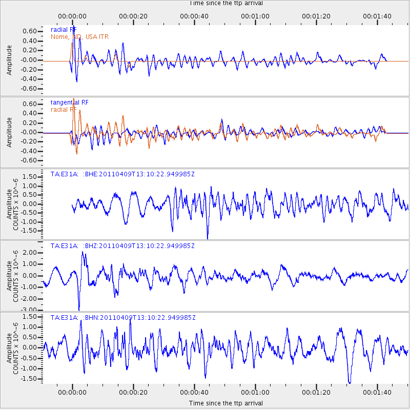
E31A Nome, ND, USA - Earthquake Result Viewer
*The percent match for this event was below the threshold and hence no stack was calculated.
| Earthquake location: |
Kyushu, Japan |
| Earthquake latitude/longitude: |
30.0/131.8 |
| Earthquake time(UTC): |
2011/04/09 (099) 12:57:48 GMT |
| Earthquake Depth: |
17 km |
| Earthquake Magnitude: |
6.1 MB, 5.6 MS, 6.0 MW, 6.0 MW |
| Earthquake Catalog/Contributor: |
WHDF/NEIC |
|
| Network: |
TA USArray Transportable Network (new EarthScope stations) |
| Station: |
E31A Nome, ND, USA |
| Lat/Lon: |
46.56 N/97.89 W |
| Elevation: |
427 m |
|
| Distance: |
91.6 deg |
| Az: |
31.752 deg |
| Baz: |
318.582 deg |
| Ray Param: |
$rayparam |
*The percent match for this event was below the threshold and hence was not used in the summary stack. |
|
| Radial Match: |
72.904884 % |
| Radial Bump: |
400 |
| Transverse Match: |
66.339386 % |
| Transverse Bump: |
400 |
| SOD ConfigId: |
356183 |
| Insert Time: |
2011-09-27 03:32:01.371 +0000 |
| GWidth: |
2.5 |
| Max Bumps: |
400 |
| Tol: |
0.001 |
|
Signal To Noise
| Channel | StoN | STA | LTA |
| TA:E31A: :BHZ:20110409T13:10:22.949985Z | 3.2988243 | 1.2184294E-6 | 3.693526E-7 |
| TA:E31A: :BHN:20110409T13:10:22.949985Z | 2.1725366 | 6.084661E-7 | 2.8007173E-7 |
| TA:E31A: :BHE:20110409T13:10:22.949985Z | 1.4188831 | 5.8697765E-7 | 4.1368995E-7 |
| Arrivals |
| Ps | |
| PpPs | |
| PsPs/PpSs | |


