You are here: Home > Network List > AR - Northern Arizona Network Stations List
> Station W13A Hualapai Mountain Park, Kingman, AZ, USA > Earthquake Result Viewer
W13A Hualapai Mountain Park, Kingman, AZ, USA - Earthquake Result Viewer
| Earthquake location: |
Eastern Honshu, Japan |
| Earthquake latitude/longitude: |
37.0/140.4 |
| Earthquake time(UTC): |
2011/04/11 (101) 08:16:12 GMT |
| Earthquake Depth: |
11 km |
| Earthquake Magnitude: |
6.4 MB, 6.5 MS, 6.6 MW, 6.6 MW |
| Earthquake Catalog/Contributor: |
WHDF/NEIC |
|
| Network: |
AR Northern Arizona Network |
| Station: |
W13A Hualapai Mountain Park, Kingman, AZ, USA |
| Lat/Lon: |
35.10 N/113.89 W |
| Elevation: |
1988 m |
|
| Distance: |
80.5 deg |
| Az: |
53.161 deg |
| Baz: |
308.613 deg |
| Ray Param: |
0.048239503 |
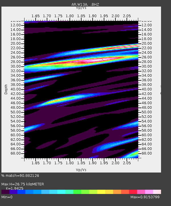
| Estimated Moho Depth: |
26.75 km |
| Estimated Crust Vp/Vs: |
1.94 |
| Assumed Crust Vp: |
6.276 km/s |
| Estimated Crust Vs: |
3.231 km/s |
| Estimated Crust Poisson's Ratio: |
0.32 |
|
| Radial Match: |
90.882126 % |
| Radial Bump: |
400 |
| Transverse Match: |
81.73856 % |
| Transverse Bump: |
400 |
| SOD ConfigId: |
356183 |
| Insert Time: |
2011-09-27 04:08:52.612 +0000 |
| GWidth: |
2.5 |
| Max Bumps: |
400 |
| Tol: |
0.001 |
|

Signal To Noise
| Channel | StoN | STA | LTA |
| AR:W13A: :BHZ:20110411T08:27:53.199971Z | 13.6032505 | 1.5302081E-6 | 1.12488415E-7 |
| AR:W13A: :BHN:20110411T08:27:53.199971Z | 4.2511444 | 4.121986E-7 | 9.6961806E-8 |
| AR:W13A: :BHE:20110411T08:27:53.199971Z | 9.408756 | 5.7850247E-7 | 6.1485544E-8 |
| Arrivals |
| Ps | 4.1 SECOND |
| PpPs | 12 SECOND |
| PsPs/PpSs | 16 SECOND |


