You are here: Home > Network List > CI - Caltech Regional Seismic Network Stations List
> Station DGR Domenigoni Reservoir, California, USA > Earthquake Result Viewer
DGR Domenigoni Reservoir, California, USA - Earthquake Result Viewer
| Earthquake location: |
Eastern Honshu, Japan |
| Earthquake latitude/longitude: |
37.0/140.4 |
| Earthquake time(UTC): |
2011/04/11 (101) 08:16:12 GMT |
| Earthquake Depth: |
11 km |
| Earthquake Magnitude: |
6.4 MB, 6.5 MS, 6.6 MW, 6.6 MW |
| Earthquake Catalog/Contributor: |
WHDF/NEIC |
|
| Network: |
CI Caltech Regional Seismic Network |
| Station: |
DGR Domenigoni Reservoir, California, USA |
| Lat/Lon: |
33.65 N/117.01 W |
| Elevation: |
609 m |
|
| Distance: |
79.3 deg |
| Az: |
55.933 deg |
| Baz: |
307.342 deg |
| Ray Param: |
0.049025193 |
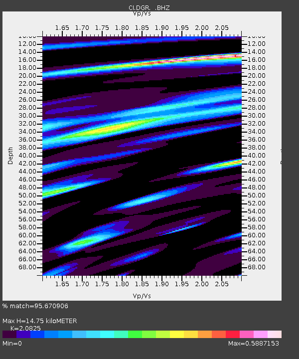
| Estimated Moho Depth: |
14.75 km |
| Estimated Crust Vp/Vs: |
2.08 |
| Assumed Crust Vp: |
6.264 km/s |
| Estimated Crust Vs: |
3.008 km/s |
| Estimated Crust Poisson's Ratio: |
0.35 |
|
| Radial Match: |
95.670906 % |
| Radial Bump: |
353 |
| Transverse Match: |
93.35866 % |
| Transverse Bump: |
400 |
| SOD ConfigId: |
356183 |
| Insert Time: |
2011-09-27 04:26:10.438 +0000 |
| GWidth: |
2.5 |
| Max Bumps: |
400 |
| Tol: |
0.001 |
|

Signal To Noise
| Channel | StoN | STA | LTA |
| CI:DGR: :BHZ:20110411T08:27:47.019978Z | 20.5789 | 2.1502335E-6 | 1.044873E-7 |
| CI:DGR: :BHN:20110411T08:27:47.019978Z | 5.1475806 | 5.662687E-7 | 1.10006766E-7 |
| CI:DGR: :BHE:20110411T08:27:47.019978Z | 11.156763 | 6.733905E-7 | 6.035716E-8 |
| Arrivals |
| Ps | 2.6 SECOND |
| PpPs | 7.1 SECOND |
| PsPs/PpSs | 9.7 SECOND |


