You are here: Home > Network List > CI - Caltech Regional Seismic Network Stations List
> Station OSI Osito Adit, California, USA > Earthquake Result Viewer
OSI Osito Adit, California, USA - Earthquake Result Viewer
| Earthquake location: |
Eastern Honshu, Japan |
| Earthquake latitude/longitude: |
37.0/140.4 |
| Earthquake time(UTC): |
2011/04/11 (101) 08:16:12 GMT |
| Earthquake Depth: |
11 km |
| Earthquake Magnitude: |
6.4 MB, 6.5 MS, 6.6 MW, 6.6 MW |
| Earthquake Catalog/Contributor: |
WHDF/NEIC |
|
| Network: |
CI Caltech Regional Seismic Network |
| Station: |
OSI Osito Adit, California, USA |
| Lat/Lon: |
34.61 N/118.72 W |
| Elevation: |
706 m |
|
| Distance: |
77.6 deg |
| Az: |
56.018 deg |
| Baz: |
306.401 deg |
| Ray Param: |
0.050192185 |
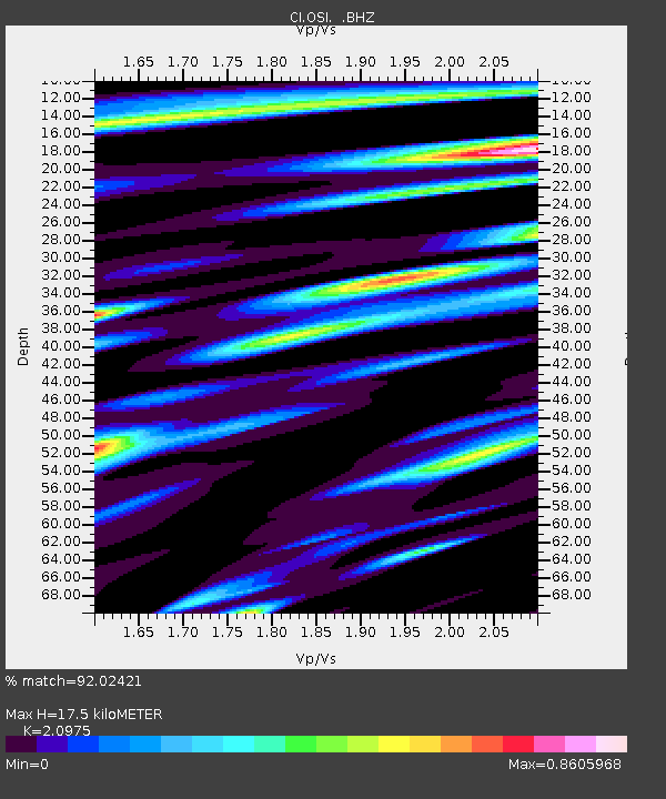
| Estimated Moho Depth: |
17.5 km |
| Estimated Crust Vp/Vs: |
2.10 |
| Assumed Crust Vp: |
6.1 km/s |
| Estimated Crust Vs: |
2.908 km/s |
| Estimated Crust Poisson's Ratio: |
0.35 |
|
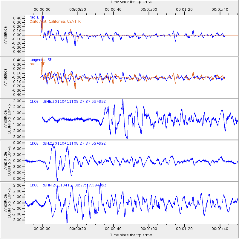
| Radial Match: |
92.02421 % |
| Radial Bump: |
400 |
| Transverse Match: |
84.62686 % |
| Transverse Bump: |
400 |
| SOD ConfigId: |
356183 |
| Insert Time: |
2011-09-27 04:26:52.404 +0000 |
| GWidth: |
2.5 |
| Max Bumps: |
400 |
| Tol: |
0.001 |
|
Signal To Noise
| Channel | StoN | STA | LTA |
| CI:OSI: :BHZ:20110411T08:27:37.59499Z | 7.158582 | 1.9691613E-6 | 2.75077E-7 |
| CI:OSI: :BHN:20110411T08:27:37.59499Z | 2.885932 | 7.009965E-7 | 2.4290125E-7 |
| CI:OSI: :BHE:20110411T08:27:37.59499Z | 2.5714233 | 4.7565763E-7 | 1.8497835E-7 |
| Arrivals |
| Ps | 3.2 SECOND |
| PpPs | 8.7 SECOND |
| PsPs/PpSs | 12 SECOND |


