You are here: Home > Network List > CI - Caltech Regional Seismic Network Stations List
> Station RCT Rector, Visalia, CA, USA > Earthquake Result Viewer
RCT Rector, Visalia, CA, USA - Earthquake Result Viewer
| Earthquake location: |
Eastern Honshu, Japan |
| Earthquake latitude/longitude: |
37.0/140.4 |
| Earthquake time(UTC): |
2011/04/11 (101) 08:16:12 GMT |
| Earthquake Depth: |
11 km |
| Earthquake Magnitude: |
6.4 MB, 6.5 MS, 6.6 MW, 6.6 MW |
| Earthquake Catalog/Contributor: |
WHDF/NEIC |
|
| Network: |
CI Caltech Regional Seismic Network |
| Station: |
RCT Rector, Visalia, CA, USA |
| Lat/Lon: |
36.31 N/119.24 W |
| Elevation: |
107 m |
|
| Distance: |
76.3 deg |
| Az: |
54.877 deg |
| Baz: |
305.843 deg |
| Ray Param: |
0.051092364 |
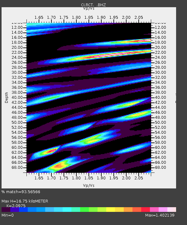
| Estimated Moho Depth: |
16.75 km |
| Estimated Crust Vp/Vs: |
2.10 |
| Assumed Crust Vp: |
6.291 km/s |
| Estimated Crust Vs: |
2.999 km/s |
| Estimated Crust Poisson's Ratio: |
0.35 |
|
| Radial Match: |
93.56566 % |
| Radial Bump: |
400 |
| Transverse Match: |
86.756615 % |
| Transverse Bump: |
400 |
| SOD ConfigId: |
356183 |
| Insert Time: |
2011-09-27 04:32:33.967 +0000 |
| GWidth: |
2.5 |
| Max Bumps: |
400 |
| Tol: |
0.001 |
|
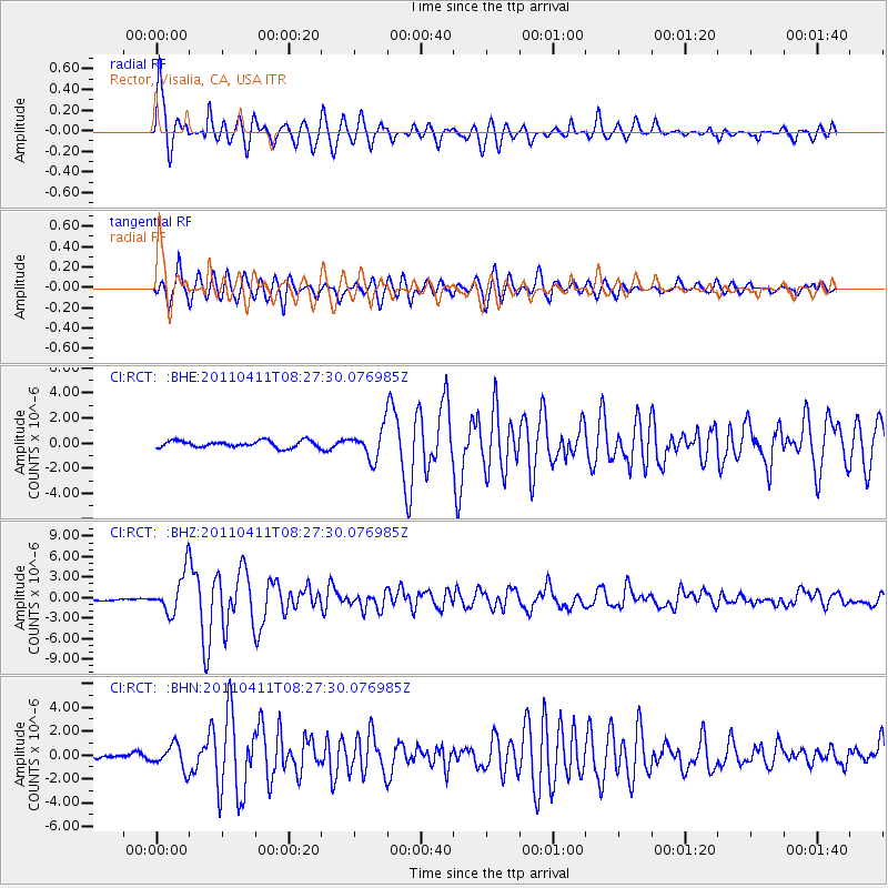
Signal To Noise
| Channel | StoN | STA | LTA |
| CI:RCT: :BHZ:20110411T08:27:30.076985Z | 17.350147 | 2.9660328E-6 | 1.7095145E-7 |
| CI:RCT: :BHN:20110411T08:27:30.076985Z | 3.8795145 | 1.0048494E-6 | 2.5901423E-7 |
| CI:RCT: :BHE:20110411T08:27:30.076985Z | 4.299627 | 1.175667E-6 | 2.7343464E-7 |
| Arrivals |
| Ps | 3.0 SECOND |
| PpPs | 8.0 SECOND |
| PsPs/PpSs | 11 SECOND |


