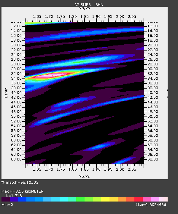
SMER AZ.SMER - Earthquake Result Viewer
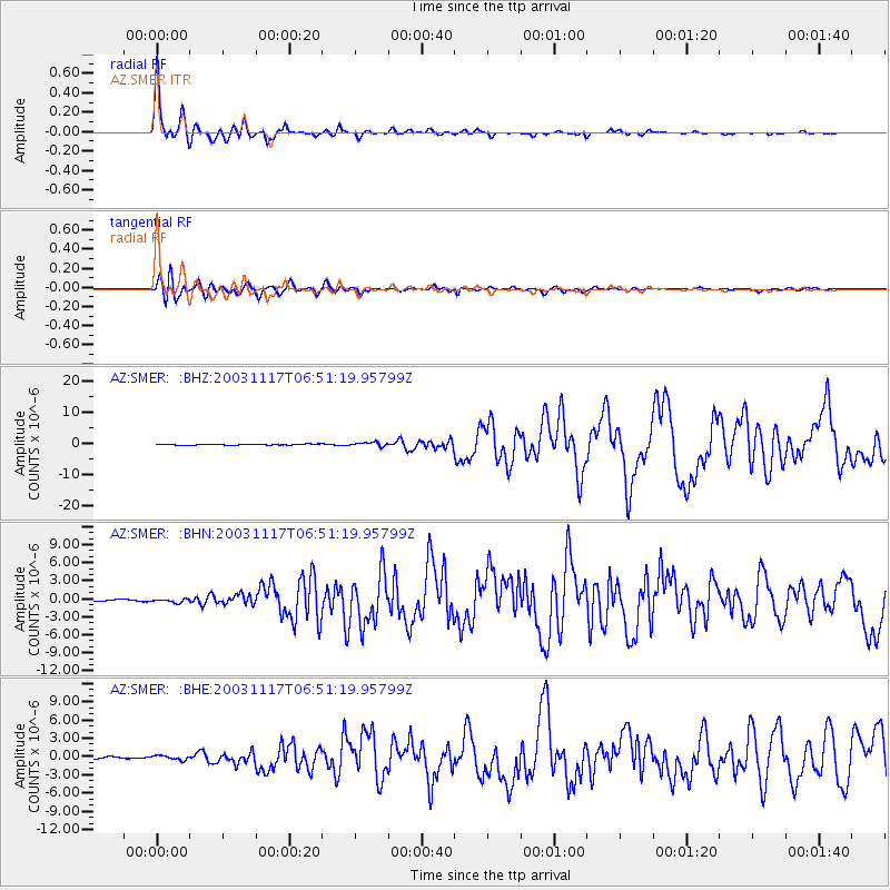
Earthquake location: Rat Islands, Aleutian Islands
Earthquake latitude/longitude: 51.1/178.6
Earthquake time(UTC): 2003/11/17 (321) 06:43:06 GMT
Earthquake Depth: 33 km
Earthquake Magnitude: 6.2 MB, 7.2 MS, 7.8 MW, 7.7 MW
Earthquake Catalog/Contributor: WHDF/NEIC
Network: AZ ANZA Regional Network
Station: SMER AZ.SMER
Lat/Lon: 33.46 N/117.17 W
Elevation: 355 m
Distance: 49.0 deg
Az: 85.226 deg
Baz: 311.336 deg
Ray Param: 0.06889501
Estimated Moho Depth: 32.5 km
Estimated Crust Vp/Vs: 1.72
Assumed Crust Vp: 6.264 km/s
Estimated Crust Vs: 3.652 km/s
Estimated Crust Poisson's Ratio: 0.24
Radial Match: 98.10163 %
Radial Bump: 354
Transverse Match: 90.4932 %
Transverse Bump: 400
SOD ConfigId: 32974
Insert Time: 2010-02-26 20:43:01.684 +0000
GWidth: 2.5
Max Bumps: 400
Tol: 0.001

Signal To Noise

ChannelStoNSTALTA
AZ:SMER: :BHN:20031117T06:51:19.95799Z1.55218032.95535E-71.9039992E-7
AZ:SMER: :BHE:20031117T06:51:19.95799Z2.0652053.4835332E-71.6867736E-7
AZ:SMER: :BHZ:20031117T06:51:19.95799Z3.71807676.384344E-71.7171094E-7
Arrivals
Ps3.9 SECOND
PpPs13 SECOND
PsPs/PpSs17 SECOND