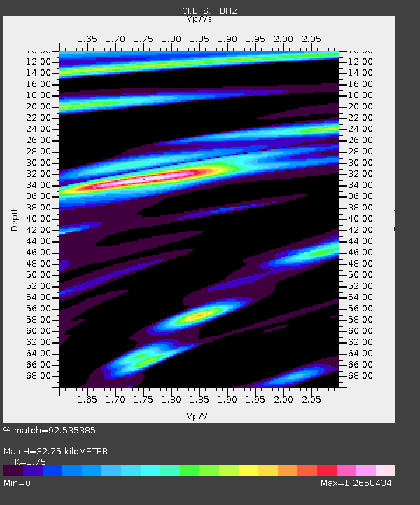
BFS Mt Baldy Forest Station - Earthquake Result Viewer

Earthquake location: Eastern Honshu, Japan
Earthquake latitude/longitude: 37.0/140.4
Earthquake time(UTC): 2011/04/11 (101) 08:16:12 GMT
Earthquake Depth: 11 km
Earthquake Magnitude: 6.4 MB, 6.5 MS, 6.6 MW, 6.6 MW
Earthquake Catalog/Contributor: WHDF/NEIC
Network: CI Caltech Regional Seismic Network
Station: BFS Mt Baldy Forest Station
Lat/Lon: 34.24 N/117.66 W
Elevation: 1312 m
Distance: 78.6 deg
Az: 55.788 deg
Baz: 306.953 deg
Ray Param: 0.049558826
Estimated Moho Depth: 32.75 km
Estimated Crust Vp/Vs: 1.75
Assumed Crust Vp: 6.276 km/s
Estimated Crust Vs: 3.586 km/s
Estimated Crust Poisson's Ratio: 0.26
Radial Match: 92.535385 %
Radial Bump: 400
Transverse Match: 89.48801 %
Transverse Bump: 400
SOD ConfigId: 356183
Insert Time: 2011-09-27 04:37:10.208 +0000
GWidth: 2.5
Max Bumps: 400
Tol: 0.001

Signal To Noise

ChannelStoNSTALTA
CI:BFS: :BHZ:20110411T08:27:42.71999Z9.5973541.8171974E-61.8934358E-7
CI:BFS: :BHN:20110411T08:27:42.71999Z1.38589062.2736623E-71.6405785E-7
CI:BFS: :BHE:20110411T08:27:42.71999Z3.84142973.7864388E-79.8568485E-8
Arrivals
Ps4.0 SECOND
PpPs14 SECOND
PsPs/PpSs18 SECOND