You are here: Home > Network List > GE - GEOFON Stations List
> Station EIL GEOFON Station Eilat, Israel > Earthquake Result Viewer
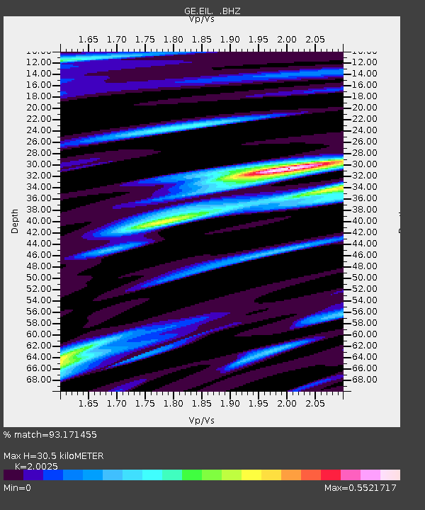
EIL GEOFON Station Eilat, Israel - Earthquake Result Viewer
| Earthquake location: |
Eastern Honshu, Japan |
| Earthquake latitude/longitude: |
37.0/140.4 |
| Earthquake time(UTC): |
2011/04/11 (101) 08:16:12 GMT |
| Earthquake Depth: |
11 km |
| Earthquake Magnitude: |
6.4 MB, 6.5 MS, 6.6 MW, 6.6 MW |
| Earthquake Catalog/Contributor: |
WHDF/NEIC |
|
| Network: |
GE GEOFON |
| Station: |
EIL GEOFON Station Eilat, Israel |
| Lat/Lon: |
29.67 N/34.95 E |
| Elevation: |
210 m |
|
| Distance: |
83.7 deg |
| Az: |
302.441 deg |
| Baz: |
50.923 deg |
| Ray Param: |
0.045991004 |
| Estimated Moho Depth: |
30.5 km |
| Estimated Crust Vp/Vs: |
2.00 |
| Assumed Crust Vp: |
6.472 km/s |
| Estimated Crust Vs: |
3.232 km/s |
| Estimated Crust Poisson's Ratio: |
0.33 |
|
| Radial Match: |
93.171455 % |
| Radial Bump: |
400 |
| Transverse Match: |
91.660736 % |
| Transverse Bump: |
400 |
| SOD ConfigId: |
356183 |
| Insert Time: |
2011-09-27 04:44:29.492 +0000 |
| GWidth: |
2.5 |
| Max Bumps: |
400 |
| Tol: |
0.001 |
|

Signal To Noise
| Channel | StoN | STA | LTA |
| GE:EIL: :BHZ:20110411T08:28:10.050007Z | 34.433777 | 2.0682537E-6 | 6.006468E-8 |
| GE:EIL: :BHN:20110411T08:28:10.050007Z | 5.4234176 | 4.4453395E-7 | 8.196565E-8 |
| GE:EIL: :BHE:20110411T08:28:10.050007Z | 9.498141 | 4.7704947E-7 | 5.022556E-8 |
| Arrivals |
| Ps | 4.8 SECOND |
| PpPs | 14 SECOND |
| PsPs/PpSs | 19 SECOND |


