You are here: Home > Network List > IW - Intermountain West Stations List
> Station MOOW Moose Ponds, Wyoming, USA > Earthquake Result Viewer
MOOW Moose Ponds, Wyoming, USA - Earthquake Result Viewer
| Earthquake location: |
Eastern Honshu, Japan |
| Earthquake latitude/longitude: |
37.0/140.4 |
| Earthquake time(UTC): |
2011/04/11 (101) 08:16:12 GMT |
| Earthquake Depth: |
11 km |
| Earthquake Magnitude: |
6.4 MB, 6.5 MS, 6.6 MW, 6.6 MW |
| Earthquake Catalog/Contributor: |
WHDF/NEIC |
|
| Network: |
IW Intermountain West |
| Station: |
MOOW Moose Ponds, Wyoming, USA |
| Lat/Lon: |
43.75 N/110.74 W |
| Elevation: |
2128 m |
|
| Distance: |
77.0 deg |
| Az: |
44.743 deg |
| Baz: |
308.956 deg |
| Ray Param: |
0.05063408 |
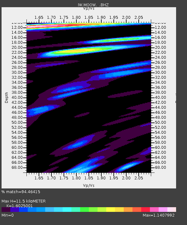
| Estimated Moho Depth: |
11.5 km |
| Estimated Crust Vp/Vs: |
1.60 |
| Assumed Crust Vp: |
6.207 km/s |
| Estimated Crust Vs: |
3.873 km/s |
| Estimated Crust Poisson's Ratio: |
0.18 |
|
| Radial Match: |
94.46415 % |
| Radial Bump: |
400 |
| Transverse Match: |
88.67051 % |
| Transverse Bump: |
370 |
| SOD ConfigId: |
356183 |
| Insert Time: |
2011-09-27 04:49:38.665 +0000 |
| GWidth: |
2.5 |
| Max Bumps: |
400 |
| Tol: |
0.001 |
|

Signal To Noise
| Channel | StoN | STA | LTA |
| IW:MOOW: :BHZ:20110411T08:27:33.909993Z | 11.659616 | 1.5965718E-6 | 1.3693176E-7 |
| IW:MOOW: :BHN:20110411T08:27:33.909993Z | 4.1663175 | 3.0813624E-7 | 7.395889E-8 |
| IW:MOOW: :BHE:20110411T08:27:33.909993Z | 2.2438216 | 3.207144E-7 | 1.4293222E-7 |
| Arrivals |
| Ps | 1.2 SECOND |
| PpPs | 4.7 SECOND |
| PsPs/PpSs | 5.8 SECOND |


