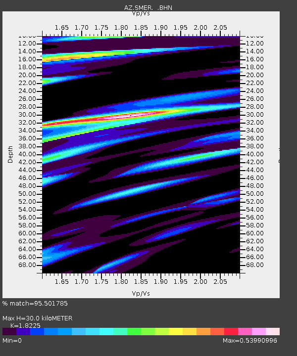
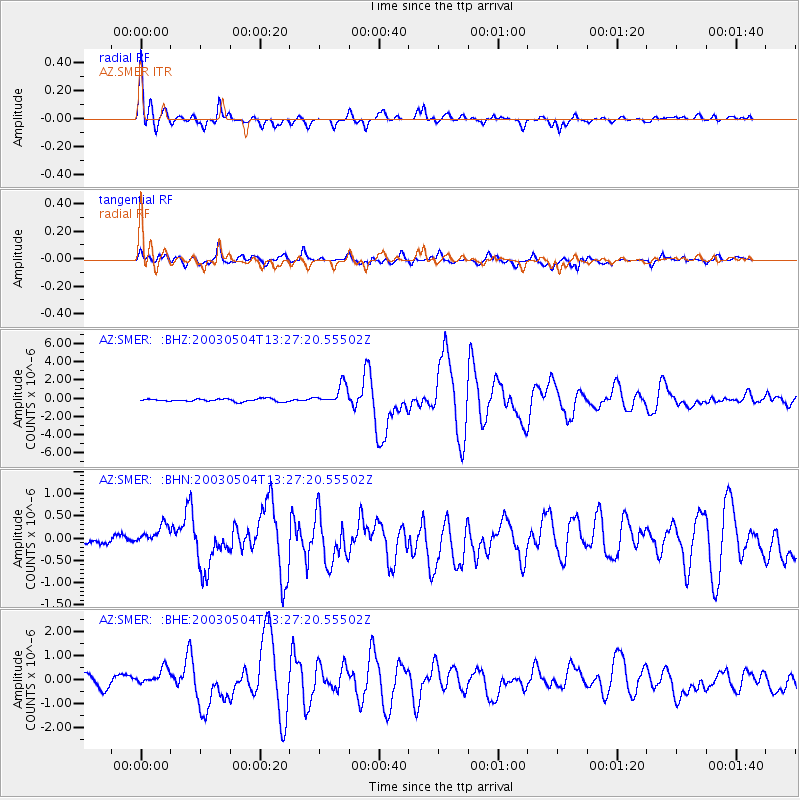
SMER AZ.SMER - Earthquake Result Viewer

Earthquake location: Kermadec Islands, New Zealand
Earthquake latitude/longitude: -30.5/-178.2
Earthquake time(UTC): 2003/05/04 (124) 13:15:18 GMT
Earthquake Depth: 62 km
Earthquake Magnitude: 6.0 MB, 6.5 MS, 6.7 MW, 6.7 MW
Earthquake Catalog/Contributor: WHDF/NEIC
Network: AZ ANZA Regional Network
Station: SMER AZ.SMER
Lat/Lon: 33.46 N/117.17 W
Elevation: 355 m
Distance: 85.9 deg
Az: 47.18 deg
Baz: 229.205 deg
Ray Param: 0.044326246
Estimated Moho Depth: 30.0 km
Estimated Crust Vp/Vs: 1.82
Assumed Crust Vp: 6.264 km/s
Estimated Crust Vs: 3.437 km/s
Estimated Crust Poisson's Ratio: 0.28
Radial Match: 95.501785 %
Radial Bump: 400
Transverse Match: 91.339005 %
Transverse Bump: 400
SOD ConfigId: 32974
Insert Time: 2010-02-26 20:43:18.648 +0000
GWidth: 2.5
Max Bumps: 400
Tol: 0.001

Signal To Noise

ChannelStoNSTALTA
AZ:SMER: :BHN:20030504T13:27:20.55502Z2.71339963.1077377E-71.1453299E-7
AZ:SMER: :BHE:20030504T13:27:20.55502Z1.62984683.8123832E-72.3391053E-7
AZ:SMER: :BHZ:20030504T13:27:20.55502Z7.38697241.0960622E-61.4837774E-7
Arrivals
Ps4.0 SECOND
PpPs13 SECOND
PsPs/PpSs17 SECOND