You are here: Home > Network List > AZ - ANZA Regional Network Stations List
> Station SMER AZ.SMER > Earthquake Result Viewer
SMER AZ.SMER - Earthquake Result Viewer
| Earthquake location: |
Near Coast Of Guatemala |
| Earthquake latitude/longitude: |
13.6/-90.8 |
| Earthquake time(UTC): |
2003/01/21 (021) 02:46:47 GMT |
| Earthquake Depth: |
24 km |
| Earthquake Magnitude: |
5.5 MB, 6.3 MS, 6.5 MW, 6.3 MW |
| Earthquake Catalog/Contributor: |
WHDF/NEIC |
|
| Network: |
AZ ANZA Regional Network |
| Station: |
SMER AZ.SMER |
| Lat/Lon: |
33.46 N/117.17 W |
| Elevation: |
355 m |
|
| Distance: |
31.1 deg |
| Az: |
313.943 deg |
| Baz: |
123.138 deg |
| Ray Param: |
0.079146296 |
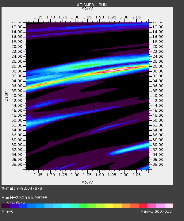
| Estimated Moho Depth: |
29.25 km |
| Estimated Crust Vp/Vs: |
1.97 |
| Assumed Crust Vp: |
6.264 km/s |
| Estimated Crust Vs: |
3.184 km/s |
| Estimated Crust Poisson's Ratio: |
0.33 |
|
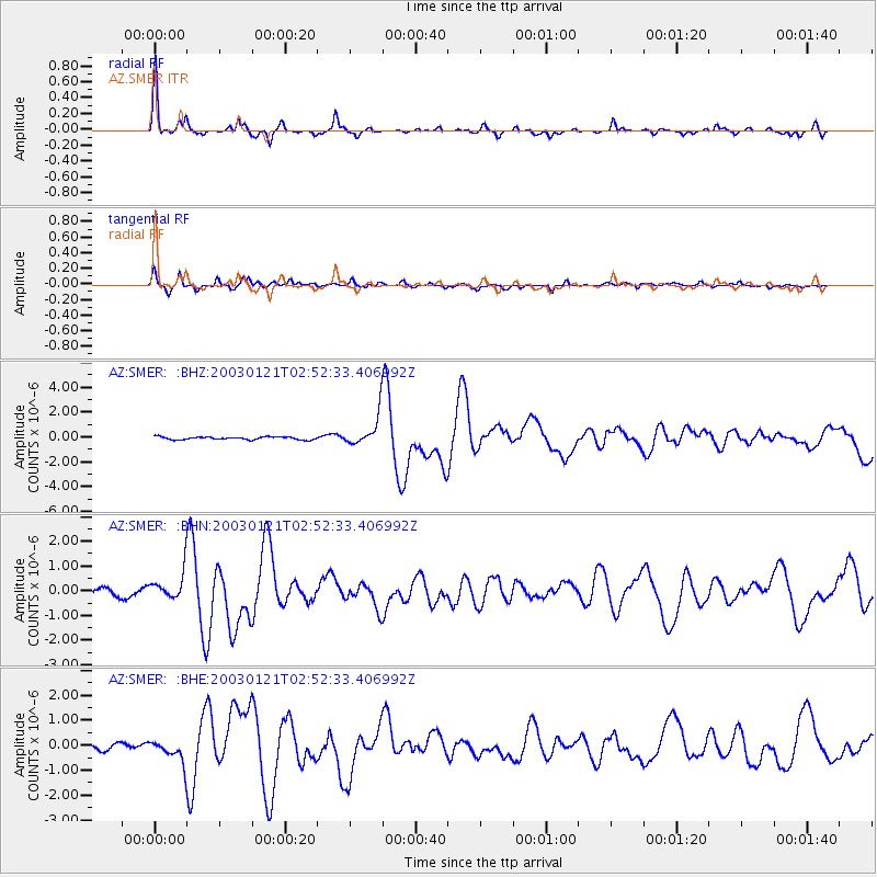
| Radial Match: |
93.047676 % |
| Radial Bump: |
267 |
| Transverse Match: |
83.88343 % |
| Transverse Bump: |
389 |
| SOD ConfigId: |
4714 |
| Insert Time: |
2010-02-26 20:43:22.006 +0000 |
| GWidth: |
2.5 |
| Max Bumps: |
400 |
| Tol: |
0.001 |
|
Signal To Noise
| Channel | StoN | STA | LTA |
| AZ:SMER: :BHN:20030121T02:52:33.406992Z | 3.4945228 | 5.660708E-7 | 1.6198801E-7 |
| AZ:SMER: :BHE:20030121T02:52:33.406992Z | 2.816446 | 4.267349E-7 | 1.5151538E-7 |
| AZ:SMER: :BHZ:20030121T02:52:33.406992Z | 10.49701 | 1.2085709E-6 | 1.1513477E-7 |
| Arrivals |
| Ps | 4.8 SECOND |
| PpPs | 13 SECOND |
| PsPs/PpSs | 18 SECOND |


