You are here: Home > Network List > MN - MEDNET Project Stations List
> Station TIP Timpagrande, Italy > Earthquake Result Viewer
TIP Timpagrande, Italy - Earthquake Result Viewer
| Earthquake location: |
Eastern Honshu, Japan |
| Earthquake latitude/longitude: |
37.0/140.4 |
| Earthquake time(UTC): |
2011/04/11 (101) 08:16:12 GMT |
| Earthquake Depth: |
11 km |
| Earthquake Magnitude: |
6.4 MB, 6.5 MS, 6.6 MW, 6.6 MW |
| Earthquake Catalog/Contributor: |
WHDF/NEIC |
|
| Network: |
MN MEDNET Project |
| Station: |
TIP Timpagrande, Italy |
| Lat/Lon: |
39.18 N/16.76 E |
| Elevation: |
789 m |
|
| Distance: |
88.1 deg |
| Az: |
319.654 deg |
| Baz: |
41.822 deg |
| Ray Param: |
0.0428007 |
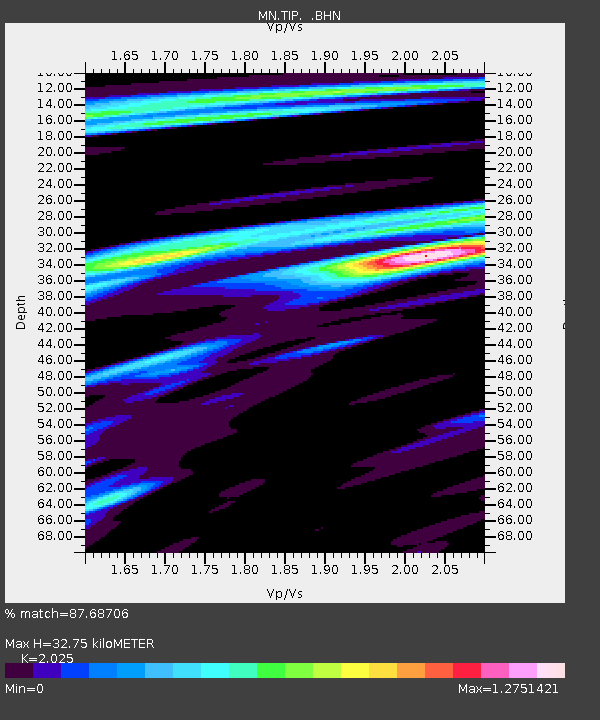
| Estimated Moho Depth: |
32.75 km |
| Estimated Crust Vp/Vs: |
2.03 |
| Assumed Crust Vp: |
6.1 km/s |
| Estimated Crust Vs: |
3.012 km/s |
| Estimated Crust Poisson's Ratio: |
0.34 |
|
| Radial Match: |
87.68706 % |
| Radial Bump: |
387 |
| Transverse Match: |
86.04085 % |
| Transverse Bump: |
400 |
| SOD ConfigId: |
356183 |
| Insert Time: |
2011-09-27 05:02:05.905 +0000 |
| GWidth: |
2.5 |
| Max Bumps: |
400 |
| Tol: |
0.001 |
|
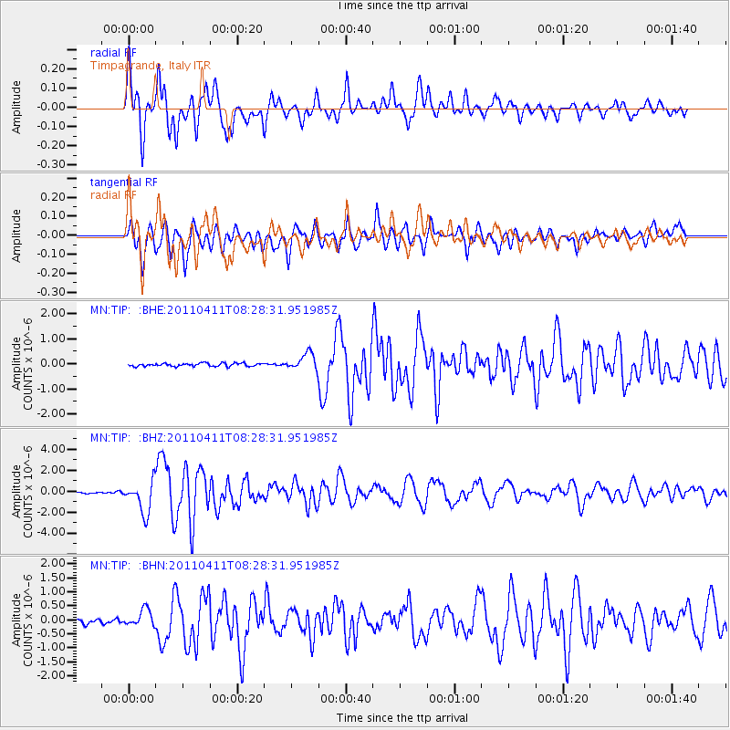
Signal To Noise
| Channel | StoN | STA | LTA |
| MN:TIP: :BHZ:20110411T08:28:31.951985Z | 16.465588 | 1.5320528E-6 | 9.304575E-8 |
| MN:TIP: :BHN:20110411T08:28:31.951985Z | 4.1113954 | 3.048527E-7 | 7.414823E-8 |
| MN:TIP: :BHE:20110411T08:28:31.951985Z | 5.5568166 | 3.3582816E-7 | 6.0435354E-8 |
| Arrivals |
| Ps | 5.6 SECOND |
| PpPs | 16 SECOND |
| PsPs/PpSs | 22 SECOND |


