You are here: Home > Network List > NE - New England Seismic Network Stations List
> Station QUA2 Belchertown, MA > Earthquake Result Viewer
QUA2 Belchertown, MA - Earthquake Result Viewer
| Earthquake location: |
Eastern Honshu, Japan |
| Earthquake latitude/longitude: |
37.0/140.4 |
| Earthquake time(UTC): |
2011/04/11 (101) 08:16:12 GMT |
| Earthquake Depth: |
11 km |
| Earthquake Magnitude: |
6.4 MB, 6.5 MS, 6.6 MW, 6.6 MW |
| Earthquake Catalog/Contributor: |
WHDF/NEIC |
|
| Network: |
NE New England Seismic Network |
| Station: |
QUA2 Belchertown, MA |
| Lat/Lon: |
42.28 N/72.35 W |
| Elevation: |
175 m |
|
| Distance: |
95.6 deg |
| Az: |
23.794 deg |
| Baz: |
334.201 deg |
| Ray Param: |
0.040732354 |
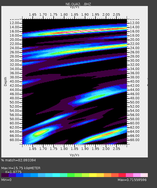
| Estimated Moho Depth: |
15.75 km |
| Estimated Crust Vp/Vs: |
1.88 |
| Assumed Crust Vp: |
6.419 km/s |
| Estimated Crust Vs: |
3.419 km/s |
| Estimated Crust Poisson's Ratio: |
0.30 |
|
| Radial Match: |
82.893394 % |
| Radial Bump: |
400 |
| Transverse Match: |
61.200115 % |
| Transverse Bump: |
400 |
| SOD ConfigId: |
356183 |
| Insert Time: |
2011-09-27 05:07:18.105 +0000 |
| GWidth: |
2.5 |
| Max Bumps: |
400 |
| Tol: |
0.001 |
|

Signal To Noise
| Channel | StoN | STA | LTA |
| NE:QUA2: :BHZ:20110411T08:29:06.370015Z | 2.8764207 | 5.6178544E-7 | 1.9530711E-7 |
| NE:QUA2: :BHN:20110411T08:29:06.370015Z | 2.4885657 | 2.2307452E-7 | 8.96398E-8 |
| NE:QUA2: :BHE:20110411T08:29:06.370015Z | 1.020597 | 1.4048257E-7 | 1.3764745E-7 |
| Arrivals |
| Ps | 2.2 SECOND |
| PpPs | 6.9 SECOND |
| PsPs/PpSs | 9.1 SECOND |


