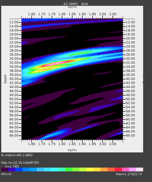
SMER AZ.SMER - Earthquake Result Viewer
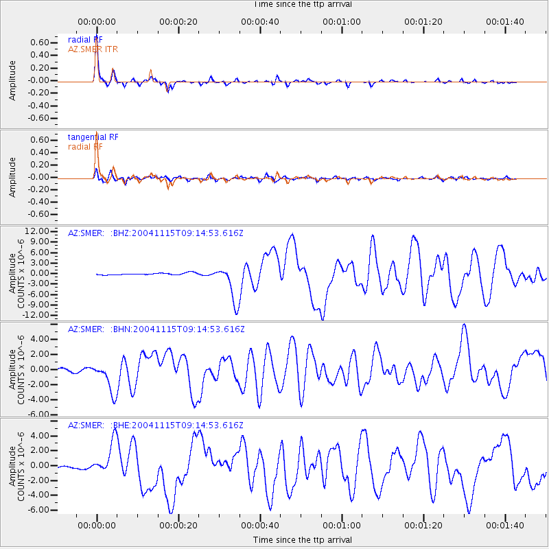
Earthquake location: Near West Coast Of Colombia
Earthquake latitude/longitude: 4.7/-77.5
Earthquake time(UTC): 2004/11/15 (320) 09:06:56 GMT
Earthquake Depth: 15 km
Earthquake Magnitude: 6.6 MB, 7.1 MS, 7.2 MW, 7.1 MW
Earthquake Catalog/Contributor: WHDF/NEIC
Network: AZ ANZA Regional Network
Station: SMER AZ.SMER
Lat/Lon: 33.46 N/117.17 W
Elevation: 355 m
Distance: 46.7 deg
Az: 312.829 deg
Baz: 119.03 deg
Ray Param: 0.07047979
Estimated Moho Depth: 32.25 km
Estimated Crust Vp/Vs: 1.76
Assumed Crust Vp: 6.264 km/s
Estimated Crust Vs: 3.549 km/s
Estimated Crust Poisson's Ratio: 0.26
Radial Match: 95.13692 %
Radial Bump: 213
Transverse Match: 81.92679 %
Transverse Bump: 400
SOD ConfigId: 2459
Insert Time: 2010-02-26 20:43:30.322 +0000
GWidth: 2.5
Max Bumps: 400
Tol: 0.001

Signal To Noise

ChannelStoNSTALTA
AZ:SMER: :BHN:20041115T09:14:53.616Z10.2323512.0221007E-61.9761838E-7
AZ:SMER: :BHE:20041115T09:14:53.616Z14.9926332.3321948E-61.5555605E-7
AZ:SMER: :BHZ:20041115T09:14:53.616Z20.1520945.527159E-62.742722E-7
Arrivals
Ps4.2 SECOND
PpPs13 SECOND
PsPs/PpSs18 SECOND