You are here: Home > Network List > TA - USArray Transportable Network (new EarthScope stations) Stations List
> Station J25A Sunshine Ranch, Edgemont, SD, USA > Earthquake Result Viewer
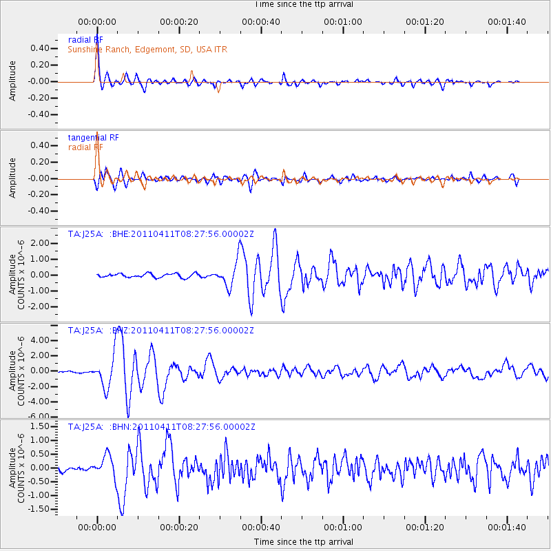
J25A Sunshine Ranch, Edgemont, SD, USA - Earthquake Result Viewer
| Earthquake location: |
Eastern Honshu, Japan |
| Earthquake latitude/longitude: |
37.0/140.4 |
| Earthquake time(UTC): |
2011/04/11 (101) 08:16:12 GMT |
| Earthquake Depth: |
11 km |
| Earthquake Magnitude: |
6.4 MB, 6.5 MS, 6.6 MW, 6.6 MW |
| Earthquake Catalog/Contributor: |
WHDF/NEIC |
|
| Network: |
TA USArray Transportable Network (new EarthScope stations) |
| Station: |
J25A Sunshine Ranch, Edgemont, SD, USA |
| Lat/Lon: |
43.39 N/103.80 W |
| Elevation: |
1220 m |
|
| Distance: |
81.0 deg |
| Az: |
41.644 deg |
| Baz: |
313.135 deg |
| Ray Param: |
0.047884274 |
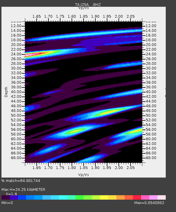
| Estimated Moho Depth: |
24.25 km |
| Estimated Crust Vp/Vs: |
1.60 |
| Assumed Crust Vp: |
6.483 km/s |
| Estimated Crust Vs: |
4.052 km/s |
| Estimated Crust Poisson's Ratio: |
0.18 |
|
| Radial Match: |
94.881744 % |
| Radial Bump: |
400 |
| Transverse Match: |
90.253044 % |
| Transverse Bump: |
400 |
| SOD ConfigId: |
356183 |
| Insert Time: |
2011-09-27 05:26:08.117 +0000 |
| GWidth: |
2.5 |
| Max Bumps: |
400 |
| Tol: |
0.001 |
|
Signal To Noise
| Channel | StoN | STA | LTA |
| TA:J25A: :BHZ:20110411T08:27:56.00002Z | 22.60167 | 2.3381915E-6 | 1.0345216E-7 |
| TA:J25A: :BHN:20110411T08:27:56.00002Z | 3.0521915 | 4.216859E-7 | 1.381584E-7 |
| TA:J25A: :BHE:20110411T08:27:56.00002Z | 6.989778 | 8.646565E-7 | 1.23703E-7 |
| Arrivals |
| Ps | 2.3 SECOND |
| PpPs | 9.4 SECOND |
| PsPs/PpSs | 12 SECOND |


