You are here: Home > Network List > TA - USArray Transportable Network (new EarthScope stations) Stations List
> Station A26A Wade Farm, Kenmare, ND, USA > Earthquake Result Viewer
A26A Wade Farm, Kenmare, ND, USA - Earthquake Result Viewer
| Earthquake location: |
Eastern Honshu, Japan |
| Earthquake latitude/longitude: |
37.0/140.4 |
| Earthquake time(UTC): |
2011/04/11 (101) 08:16:12 GMT |
| Earthquake Depth: |
11 km |
| Earthquake Magnitude: |
6.4 MB, 6.5 MS, 6.6 MW, 6.6 MW |
| Earthquake Catalog/Contributor: |
WHDF/NEIC |
|
| Network: |
TA USArray Transportable Network (new EarthScope stations) |
| Station: |
A26A Wade Farm, Kenmare, ND, USA |
| Lat/Lon: |
48.90 N/102.04 W |
| Elevation: |
570 m |
|
| Distance: |
78.1 deg |
| Az: |
36.714 deg |
| Baz: |
313.511 deg |
| Ray Param: |
0.0498537 |
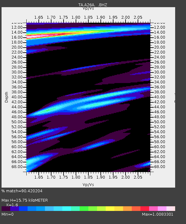
| Estimated Moho Depth: |
15.75 km |
| Estimated Crust Vp/Vs: |
1.60 |
| Assumed Crust Vp: |
6.438 km/s |
| Estimated Crust Vs: |
4.023 km/s |
| Estimated Crust Poisson's Ratio: |
0.18 |
|
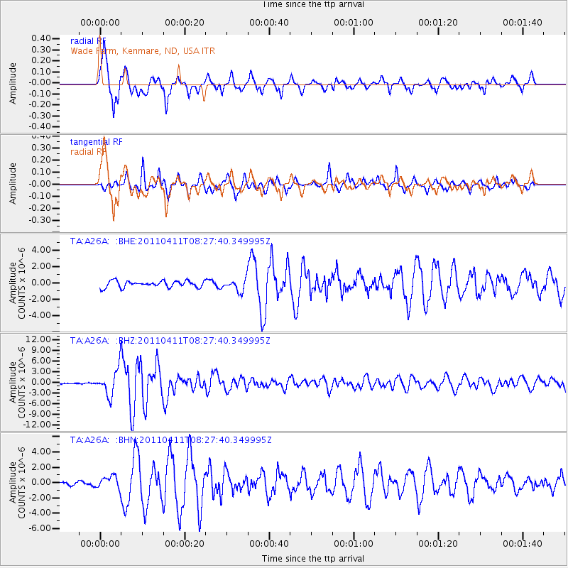
| Radial Match: |
90.420204 % |
| Radial Bump: |
393 |
| Transverse Match: |
88.30018 % |
| Transverse Bump: |
386 |
| SOD ConfigId: |
356183 |
| Insert Time: |
2011-09-27 05:32:51.187 +0000 |
| GWidth: |
2.5 |
| Max Bumps: |
400 |
| Tol: |
0.001 |
|
Signal To Noise
| Channel | StoN | STA | LTA |
| TA:A26A: :BHZ:20110411T08:27:40.349995Z | 17.398106 | 3.9020165E-6 | 2.2427824E-7 |
| TA:A26A: :BHN:20110411T08:27:40.349995Z | 1.5089664 | 8.0382944E-7 | 5.3270196E-7 |
| TA:A26A: :BHE:20110411T08:27:40.349995Z | 1.9269092 | 7.701378E-7 | 3.9967517E-7 |
| Arrivals |
| Ps | 1.5 SECOND |
| PpPs | 6.2 SECOND |
| PsPs/PpSs | 7.7 SECOND |


