You are here: Home > Network List > TA - USArray Transportable Network (new EarthScope stations) Stations List
> Station C26A Wahner Farm, Parshall, ND, USA > Earthquake Result Viewer
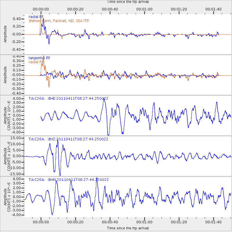
C26A Wahner Farm, Parshall, ND, USA - Earthquake Result Viewer
*The percent match for this event was below the threshold and hence no stack was calculated.
| Earthquake location: |
Eastern Honshu, Japan |
| Earthquake latitude/longitude: |
37.0/140.4 |
| Earthquake time(UTC): |
2011/04/11 (101) 08:16:12 GMT |
| Earthquake Depth: |
11 km |
| Earthquake Magnitude: |
6.4 MB, 6.5 MS, 6.6 MW, 6.6 MW |
| Earthquake Catalog/Contributor: |
WHDF/NEIC |
|
| Network: |
TA USArray Transportable Network (new EarthScope stations) |
| Station: |
C26A Wahner Farm, Parshall, ND, USA |
| Lat/Lon: |
47.83 N/102.10 W |
| Elevation: |
656 m |
|
| Distance: |
78.8 deg |
| Az: |
37.534 deg |
| Baz: |
313.632 deg |
| Ray Param: |
$rayparam |
*The percent match for this event was below the threshold and hence was not used in the summary stack. |
|
| Radial Match: |
89.920204 % |
| Radial Bump: |
361 |
| Transverse Match: |
80.35247 % |
| Transverse Bump: |
400 |
| SOD ConfigId: |
356183 |
| Insert Time: |
2011-09-27 05:33:22.567 +0000 |
| GWidth: |
2.5 |
| Max Bumps: |
400 |
| Tol: |
0.001 |
|
Signal To Noise
| Channel | StoN | STA | LTA |
| TA:C26A: :BHZ:20110411T08:27:44.25002Z | 19.949867 | 3.8485086E-6 | 1.92909E-7 |
| TA:C26A: :BHN:20110411T08:27:44.25002Z | 1.7869718 | 8.65712E-7 | 4.844576E-7 |
| TA:C26A: :BHE:20110411T08:27:44.25002Z | 0.92302984 | 6.47562E-7 | 7.015613E-7 |
| Arrivals |
| Ps | |
| PpPs | |
| PsPs/PpSs | |


