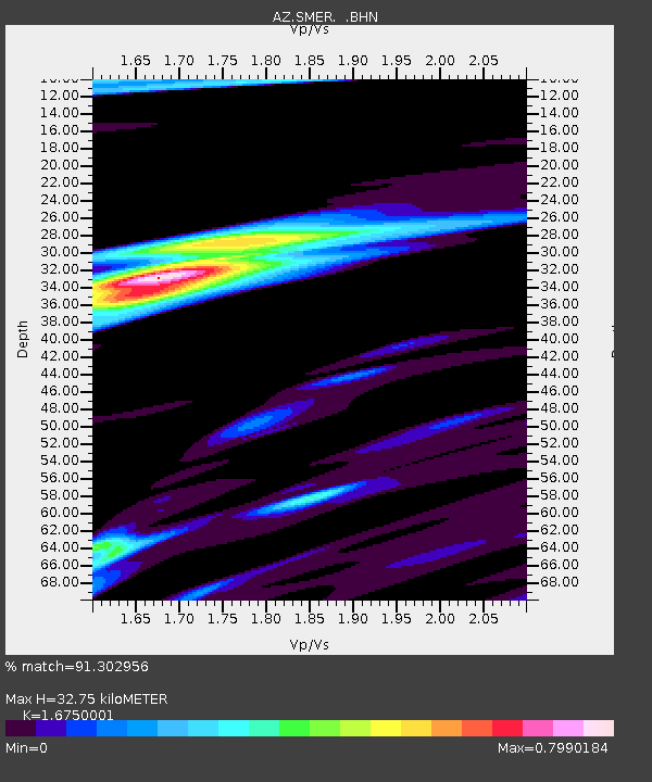
SMER AZ.SMER - Earthquake Result Viewer
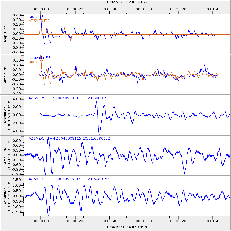
Earthquake location: Near S. Coast Of Honshu, Japan
Earthquake latitude/longitude: 33.1/137.2
Earthquake time(UTC): 2004/09/08 (252) 14:58:25 GMT
Earthquake Depth: 21 km
Earthquake Magnitude: 6.2 MB, 5.8 MS, 6.2 MW, 6.1 MW
Earthquake Catalog/Contributor: WHDF/NEIC
Network: AZ ANZA Regional Network
Station: SMER AZ.SMER
Lat/Lon: 33.46 N/117.17 W
Elevation: 355 m
Distance: 83.7 deg
Az: 54.092 deg
Baz: 305.621 deg
Ray Param: 0.045976367
Estimated Moho Depth: 32.75 km
Estimated Crust Vp/Vs: 1.68
Assumed Crust Vp: 6.264 km/s
Estimated Crust Vs: 3.739 km/s
Estimated Crust Poisson's Ratio: 0.22
Radial Match: 91.302956 %
Radial Bump: 368
Transverse Match: 69.05146 %
Transverse Bump: 400
SOD ConfigId: 2459
Insert Time: 2010-02-26 20:43:39.221 +0000
GWidth: 2.5
Max Bumps: 400
Tol: 0.001

Signal To Noise

ChannelStoNSTALTA
AZ:SMER: :BHN:20040908T15:10:21.608015Z5.57779556.9581324E-71.24747E-7
AZ:SMER: :BHE:20040908T15:10:21.608015Z3.47294648.384452E-72.4142187E-7
AZ:SMER: :BHZ:20040908T15:10:21.608015Z12.4382432.4833096E-61.9965115E-7
Arrivals
Ps3.6 SECOND
PpPs14 SECOND
PsPs/PpSs17 SECOND