You are here: Home > Network List > TA - USArray Transportable Network (new EarthScope stations) Stations List
> Station B28A Dugan Ranch, Towner, ND, USA > Earthquake Result Viewer
B28A Dugan Ranch, Towner, ND, USA - Earthquake Result Viewer
| Earthquake location: |
Eastern Honshu, Japan |
| Earthquake latitude/longitude: |
37.0/140.4 |
| Earthquake time(UTC): |
2011/04/11 (101) 08:16:12 GMT |
| Earthquake Depth: |
11 km |
| Earthquake Magnitude: |
6.4 MB, 6.5 MS, 6.6 MW, 6.6 MW |
| Earthquake Catalog/Contributor: |
WHDF/NEIC |
|
| Network: |
TA USArray Transportable Network (new EarthScope stations) |
| Station: |
B28A Dugan Ranch, Towner, ND, USA |
| Lat/Lon: |
48.45 N/100.36 W |
| Elevation: |
451 m |
|
| Distance: |
79.2 deg |
| Az: |
36.254 deg |
| Baz: |
314.676 deg |
| Ray Param: |
0.04909892 |
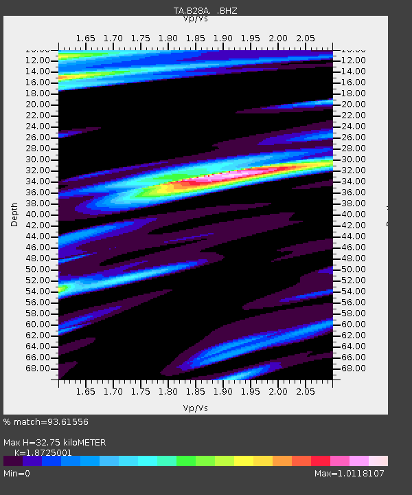
| Estimated Moho Depth: |
32.75 km |
| Estimated Crust Vp/Vs: |
1.87 |
| Assumed Crust Vp: |
6.438 km/s |
| Estimated Crust Vs: |
3.438 km/s |
| Estimated Crust Poisson's Ratio: |
0.30 |
|
| Radial Match: |
93.61556 % |
| Radial Bump: |
305 |
| Transverse Match: |
91.58635 % |
| Transverse Bump: |
371 |
| SOD ConfigId: |
356183 |
| Insert Time: |
2011-09-27 05:36:33.754 +0000 |
| GWidth: |
2.5 |
| Max Bumps: |
400 |
| Tol: |
0.001 |
|

Signal To Noise
| Channel | StoN | STA | LTA |
| TA:B28A: :BHZ:20110411T08:27:46.449971Z | 25.25403 | 3.4900188E-6 | 1.3819651E-7 |
| TA:B28A: :BHN:20110411T08:27:46.449971Z | 2.5667353 | 1.3557117E-6 | 5.2818524E-7 |
| TA:B28A: :BHE:20110411T08:27:46.449971Z | 1.7705628 | 1.0165452E-6 | 5.741368E-7 |
| Arrivals |
| Ps | 4.6 SECOND |
| PpPs | 14 SECOND |
| PsPs/PpSs | 19 SECOND |


