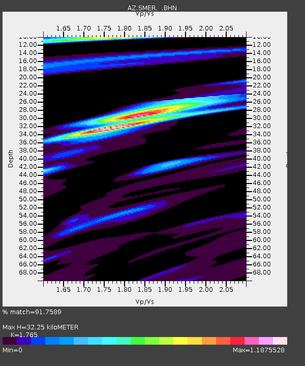
SMER AZ.SMER - Earthquake Result Viewer
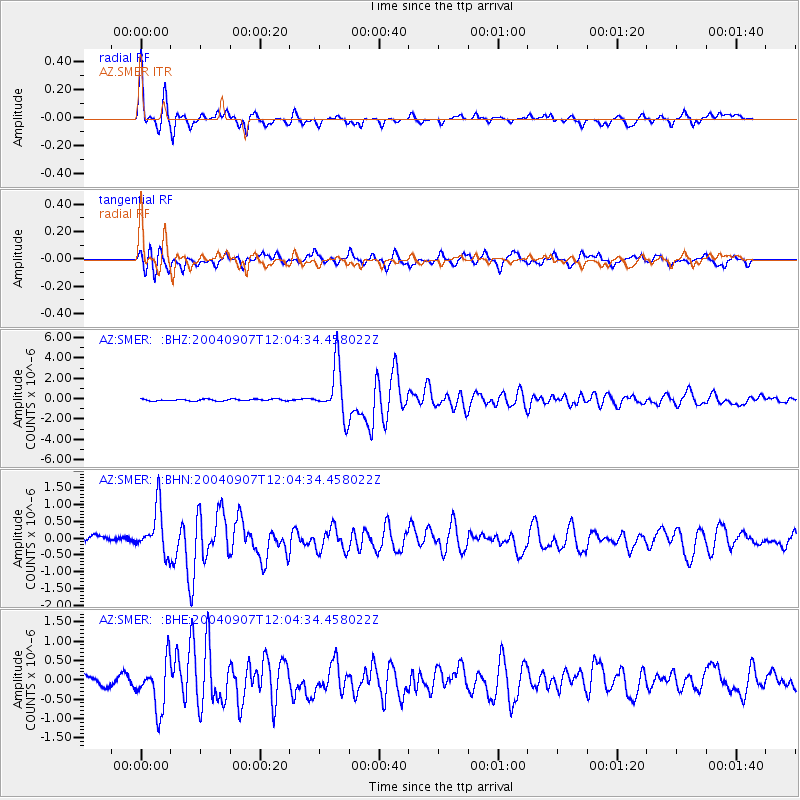
Earthquake location: Santiago Del Estero Prov., Arg.
Earthquake latitude/longitude: -28.6/-65.8
Earthquake time(UTC): 2004/09/07 (251) 11:53:06 GMT
Earthquake Depth: 22 km
Earthquake Magnitude: 6.1 MB, 6.1 MS, 6.4 MW, 6.2 MW
Earthquake Catalog/Contributor: WHDF/NEIC
Network: AZ ANZA Regional Network
Station: SMER AZ.SMER
Lat/Lon: 33.46 N/117.17 W
Elevation: 355 m
Distance: 78.6 deg
Az: 318.245 deg
Baz: 135.521 deg
Ray Param: 0.0495349
Estimated Moho Depth: 32.25 km
Estimated Crust Vp/Vs: 1.76
Assumed Crust Vp: 6.264 km/s
Estimated Crust Vs: 3.549 km/s
Estimated Crust Poisson's Ratio: 0.26
Radial Match: 91.7589 %
Radial Bump: 351
Transverse Match: 76.7473 %
Transverse Bump: 400
SOD ConfigId: 2459
Insert Time: 2010-02-26 20:43:40.899 +0000
GWidth: 2.5
Max Bumps: 400
Tol: 0.001

Signal To Noise

ChannelStoNSTALTA
AZ:SMER: :BHN:20040907T12:04:34.458022Z4.38375046.9818526E-71.5926666E-7
AZ:SMER: :BHE:20040907T12:04:34.458022Z4.83033136.058819E-71.2543278E-7
AZ:SMER: :BHZ:20040907T12:04:34.458022Z28.9386712.5059633E-68.6595655E-8
Arrivals
Ps4.1 SECOND
PpPs14 SECOND
PsPs/PpSs18 SECOND