You are here: Home > Network List > TA - USArray Transportable Network (new EarthScope stations) Stations List
> Station E30A Jud, ND, USA > Earthquake Result Viewer
E30A Jud, ND, USA - Earthquake Result Viewer
| Earthquake location: |
Eastern Honshu, Japan |
| Earthquake latitude/longitude: |
37.0/140.4 |
| Earthquake time(UTC): |
2011/04/11 (101) 08:16:12 GMT |
| Earthquake Depth: |
11 km |
| Earthquake Magnitude: |
6.4 MB, 6.5 MS, 6.6 MW, 6.6 MW |
| Earthquake Catalog/Contributor: |
WHDF/NEIC |
|
| Network: |
TA USArray Transportable Network (new EarthScope stations) |
| Station: |
E30A Jud, ND, USA |
| Lat/Lon: |
46.50 N/98.91 W |
| Elevation: |
544 m |
|
| Distance: |
81.3 deg |
| Az: |
36.935 deg |
| Baz: |
315.858 deg |
| Ray Param: |
0.047674093 |
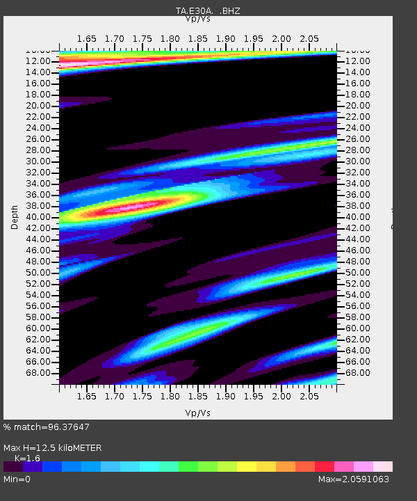
| Estimated Moho Depth: |
12.5 km |
| Estimated Crust Vp/Vs: |
1.60 |
| Assumed Crust Vp: |
6.53 km/s |
| Estimated Crust Vs: |
4.082 km/s |
| Estimated Crust Poisson's Ratio: |
0.18 |
|
| Radial Match: |
96.37647 % |
| Radial Bump: |
336 |
| Transverse Match: |
80.13544 % |
| Transverse Bump: |
400 |
| SOD ConfigId: |
356183 |
| Insert Time: |
2011-09-27 05:38:48.191 +0000 |
| GWidth: |
2.5 |
| Max Bumps: |
400 |
| Tol: |
0.001 |
|
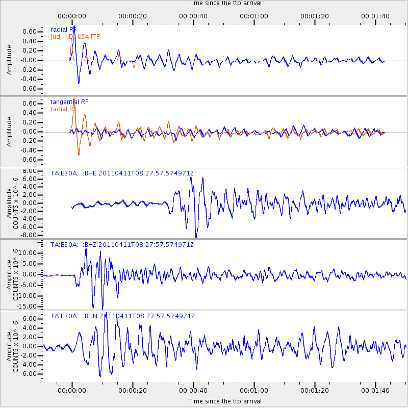
Signal To Noise
| Channel | StoN | STA | LTA |
| TA:E30A: :BHZ:20110411T08:27:57.574971Z | 18.793045 | 4.421509E-6 | 2.3527369E-7 |
| TA:E30A: :BHN:20110411T08:27:57.574971Z | 3.5095215 | 1.8751307E-6 | 5.342981E-7 |
| TA:E30A: :BHE:20110411T08:27:57.574971Z | 3.630541 | 1.5745318E-6 | 4.3369064E-7 |
| Arrivals |
| Ps | 1.2 SECOND |
| PpPs | 4.8 SECOND |
| PsPs/PpSs | 6.0 SECOND |


