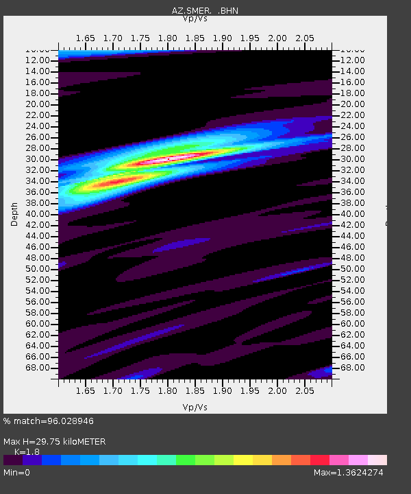
SMER AZ.SMER - Earthquake Result Viewer
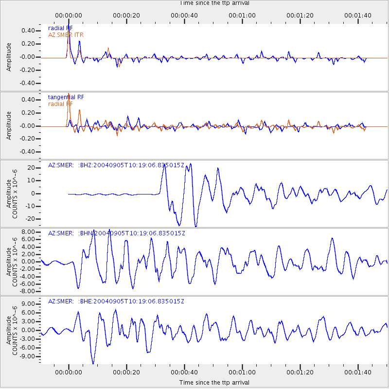
Earthquake location: Near S. Coast Of Western Honshu
Earthquake latitude/longitude: 33.1/136.6
Earthquake time(UTC): 2004/09/05 (249) 10:07:07 GMT
Earthquake Depth: 14 km
Earthquake Magnitude: 6.7 MB, 7.0 MS, 7.2 MW, 7.0 MW
Earthquake Catalog/Contributor: WHDF/NEIC
Network: AZ ANZA Regional Network
Station: SMER AZ.SMER
Lat/Lon: 33.46 N/117.17 W
Elevation: 355 m
Distance: 84.1 deg
Az: 53.8 deg
Baz: 305.853 deg
Ray Param: 0.04568309
Estimated Moho Depth: 29.75 km
Estimated Crust Vp/Vs: 1.80
Assumed Crust Vp: 6.264 km/s
Estimated Crust Vs: 3.48 km/s
Estimated Crust Poisson's Ratio: 0.28
Radial Match: 96.028946 %
Radial Bump: 320
Transverse Match: 93.78053 %
Transverse Bump: 400
SOD ConfigId: 2459
Insert Time: 2010-02-26 20:43:44.631 +0000
GWidth: 2.5
Max Bumps: 400
Tol: 0.001

Signal To Noise

ChannelStoNSTALTA
AZ:SMER: :BHN:20040905T10:19:06.835015Z9.1693373.2332575E-63.5261627E-7
AZ:SMER: :BHE:20040905T10:19:06.835015Z4.65317252.850374E-66.1256566E-7
AZ:SMER: :BHZ:20040905T10:19:06.835015Z33.0838621.0551256E-53.1892455E-7
Arrivals
Ps3.9 SECOND
PpPs13 SECOND
PsPs/PpSs17 SECOND