You are here: Home > Network List > TA - USArray Transportable Network (new EarthScope stations) Stations List
> Station M31A Lambtecht Ranch, Loup City, NE, USA > Earthquake Result Viewer
M31A Lambtecht Ranch, Loup City, NE, USA - Earthquake Result Viewer
| Earthquake location: |
Eastern Honshu, Japan |
| Earthquake latitude/longitude: |
37.0/140.4 |
| Earthquake time(UTC): |
2011/04/11 (101) 08:16:12 GMT |
| Earthquake Depth: |
11 km |
| Earthquake Magnitude: |
6.4 MB, 6.5 MS, 6.6 MW, 6.6 MW |
| Earthquake Catalog/Contributor: |
WHDF/NEIC |
|
| Network: |
TA USArray Transportable Network (new EarthScope stations) |
| Station: |
M31A Lambtecht Ranch, Loup City, NE, USA |
| Lat/Lon: |
41.34 N/98.98 W |
| Elevation: |
699 m |
|
| Distance: |
85.0 deg |
| Az: |
40.574 deg |
| Baz: |
316.246 deg |
| Ray Param: |
0.04508358 |
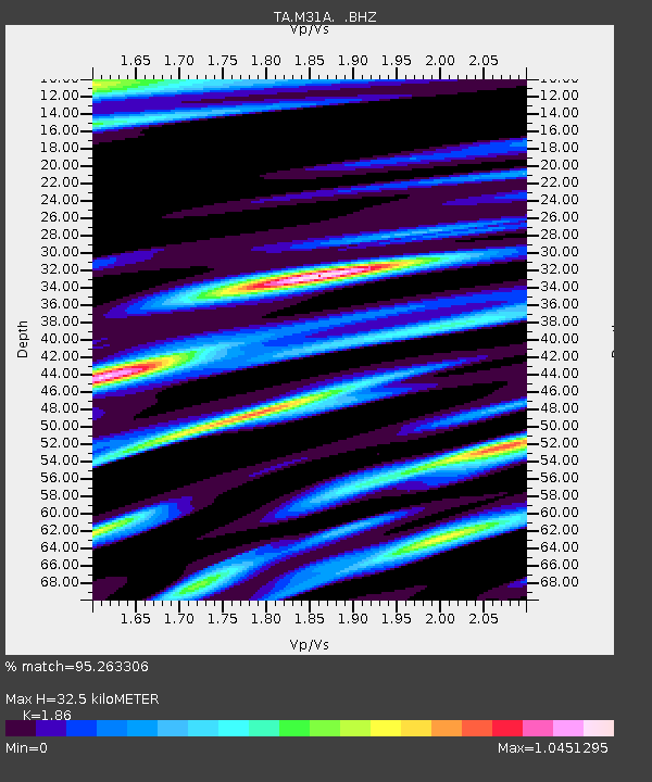
| Estimated Moho Depth: |
32.5 km |
| Estimated Crust Vp/Vs: |
1.86 |
| Assumed Crust Vp: |
6.53 km/s |
| Estimated Crust Vs: |
3.511 km/s |
| Estimated Crust Poisson's Ratio: |
0.30 |
|
| Radial Match: |
95.263306 % |
| Radial Bump: |
319 |
| Transverse Match: |
86.48955 % |
| Transverse Bump: |
395 |
| SOD ConfigId: |
356183 |
| Insert Time: |
2011-09-27 05:41:10.138 +0000 |
| GWidth: |
2.5 |
| Max Bumps: |
400 |
| Tol: |
0.001 |
|
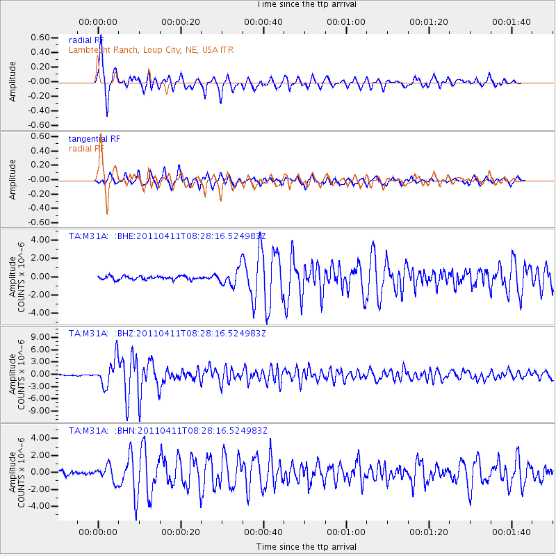
Signal To Noise
| Channel | StoN | STA | LTA |
| TA:M31A: :BHZ:20110411T08:28:16.524983Z | 33.07273 | 3.3764586E-6 | 1.0209192E-7 |
| TA:M31A: :BHN:20110411T08:28:16.524983Z | 3.1043012 | 9.328167E-7 | 3.0049168E-7 |
| TA:M31A: :BHE:20110411T08:28:16.524983Z | 5.4926033 | 9.995197E-7 | 1.8197558E-7 |
| Arrivals |
| Ps | 4.4 SECOND |
| PpPs | 14 SECOND |
| PsPs/PpSs | 18 SECOND |


