You are here: Home > Network List > TA - USArray Transportable Network (new EarthScope stations) Stations List
> Station L31A Butterfield Farm, Chambers, NE, USA > Earthquake Result Viewer
L31A Butterfield Farm, Chambers, NE, USA - Earthquake Result Viewer

| Earthquake location: |
Eastern Honshu, Japan |
| Earthquake latitude/longitude: |
37.0/140.4 |
| Earthquake time(UTC): |
2011/04/11 (101) 08:16:12 GMT |
| Earthquake Depth: |
11 km |
| Earthquake Magnitude: |
6.4 MB, 6.5 MS, 6.6 MW, 6.6 MW |
| Earthquake Catalog/Contributor: |
WHDF/NEIC |
|
| Network: |
TA USArray Transportable Network (new EarthScope stations) |
| Station: |
L31A Butterfield Farm, Chambers, NE, USA |
| Lat/Lon: |
42.18 N/98.84 W |
| Elevation: |
670 m |
|
| Distance: |
84.5 deg |
| Az: |
39.922 deg |
| Baz: |
316.278 deg |
| Ray Param: |
0.045464136 |
| Estimated Moho Depth: |
10.25 km |
| Estimated Crust Vp/Vs: |
1.79 |
| Assumed Crust Vp: |
6.53 km/s |
| Estimated Crust Vs: |
3.643 km/s |
| Estimated Crust Poisson's Ratio: |
0.27 |
|
| Radial Match: |
96.07608 % |
| Radial Bump: |
331 |
| Transverse Match: |
92.34692 % |
| Transverse Bump: |
400 |
| SOD ConfigId: |
356183 |
| Insert Time: |
2011-09-27 05:41:58.446 +0000 |
| GWidth: |
2.5 |
| Max Bumps: |
400 |
| Tol: |
0.001 |
|
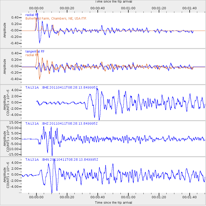
Signal To Noise
| Channel | StoN | STA | LTA |
| TA:L31A: :BHZ:20110411T08:28:13.849995Z | 48.61822 | 3.9320003E-6 | 8.0875026E-8 |
| TA:L31A: :BHN:20110411T08:28:13.849995Z | 7.072292 | 1.1439195E-6 | 1.6174664E-7 |
| TA:L31A: :BHE:20110411T08:28:13.849995Z | 4.4392524 | 1.2752839E-6 | 2.872745E-7 |
| Arrivals |
| Ps | 1.3 SECOND |
| PpPs | 4.3 SECOND |
| PsPs/PpSs | 5.5 SECOND |


