You are here: Home > Network List > TA - USArray Transportable Network (new EarthScope stations) Stations List
> Station I29A Vivian, Onida, SD, USA > Earthquake Result Viewer
I29A Vivian, Onida, SD, USA - Earthquake Result Viewer
| Earthquake location: |
Eastern Honshu, Japan |
| Earthquake latitude/longitude: |
37.0/140.4 |
| Earthquake time(UTC): |
2011/04/11 (101) 08:16:12 GMT |
| Earthquake Depth: |
11 km |
| Earthquake Magnitude: |
6.4 MB, 6.5 MS, 6.6 MW, 6.6 MW |
| Earthquake Catalog/Contributor: |
WHDF/NEIC |
|
| Network: |
TA USArray Transportable Network (new EarthScope stations) |
| Station: |
I29A Vivian, Onida, SD, USA |
| Lat/Lon: |
44.02 N/100.30 W |
| Elevation: |
592 m |
|
| Distance: |
82.4 deg |
| Az: |
39.4 deg |
| Baz: |
315.221 deg |
| Ray Param: |
0.046917282 |
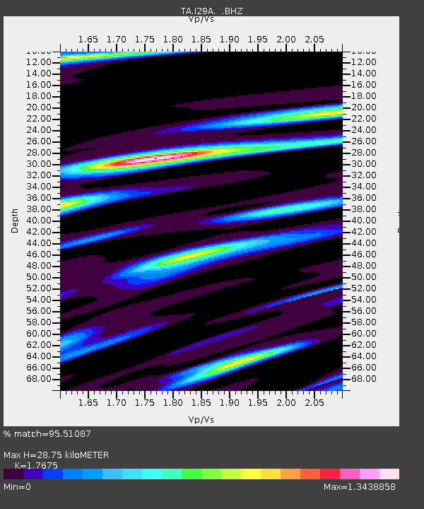
| Estimated Moho Depth: |
28.75 km |
| Estimated Crust Vp/Vs: |
1.77 |
| Assumed Crust Vp: |
6.53 km/s |
| Estimated Crust Vs: |
3.695 km/s |
| Estimated Crust Poisson's Ratio: |
0.26 |
|
| Radial Match: |
95.51087 % |
| Radial Bump: |
400 |
| Transverse Match: |
88.59291 % |
| Transverse Bump: |
400 |
| SOD ConfigId: |
356183 |
| Insert Time: |
2011-09-27 05:42:51.810 +0000 |
| GWidth: |
2.5 |
| Max Bumps: |
400 |
| Tol: |
0.001 |
|
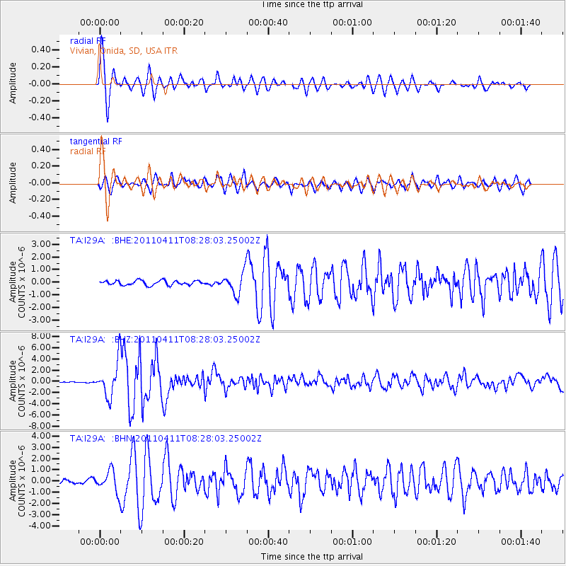
Signal To Noise
| Channel | StoN | STA | LTA |
| TA:I29A: :BHZ:20110411T08:28:03.25002Z | 29.08286 | 3.226145E-6 | 1.1092942E-7 |
| TA:I29A: :BHN:20110411T08:28:03.25002Z | 6.1228228 | 9.826675E-7 | 1.6049256E-7 |
| TA:I29A: :BHE:20110411T08:28:03.25002Z | 5.1000037 | 9.0568403E-7 | 1.7758498E-7 |
| Arrivals |
| Ps | 3.5 SECOND |
| PpPs | 12 SECOND |
| PsPs/PpSs | 15 SECOND |


