You are here: Home > Network List > AZ - ANZA Regional Network Stations List
> Station SMER AZ.SMER > Earthquake Result Viewer
SMER AZ.SMER - Earthquake Result Viewer
| Earthquake location: |
Off Coast Of Costa Rica |
| Earthquake latitude/longitude: |
10.7/-87.0 |
| Earthquake time(UTC): |
2004/06/29 (181) 07:01:30 GMT |
| Earthquake Depth: |
9.0 km |
| Earthquake Magnitude: |
5.8 MB, 5.8 MS, 6.3 MW, 6.1 MW |
| Earthquake Catalog/Contributor: |
WHDF/NEIC |
|
| Network: |
AZ ANZA Regional Network |
| Station: |
SMER AZ.SMER |
| Lat/Lon: |
33.46 N/117.17 W |
| Elevation: |
355 m |
|
| Distance: |
35.7 deg |
| Az: |
314.014 deg |
| Baz: |
122.286 deg |
| Ray Param: |
0.07708758 |
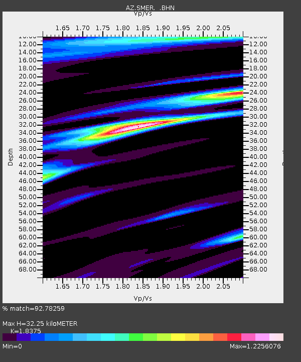
| Estimated Moho Depth: |
32.25 km |
| Estimated Crust Vp/Vs: |
1.84 |
| Assumed Crust Vp: |
6.264 km/s |
| Estimated Crust Vs: |
3.409 km/s |
| Estimated Crust Poisson's Ratio: |
0.29 |
|
| Radial Match: |
92.78259 % |
| Radial Bump: |
243 |
| Transverse Match: |
84.46617 % |
| Transverse Bump: |
400 |
| SOD ConfigId: |
2459 |
| Insert Time: |
2010-02-26 20:43:49.351 +0000 |
| GWidth: |
2.5 |
| Max Bumps: |
400 |
| Tol: |
0.001 |
|
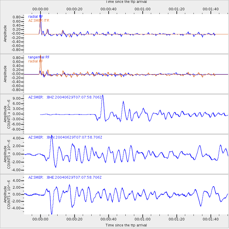
Signal To Noise
| Channel | StoN | STA | LTA |
| AZ:SMER: :BHN:20040629T07:07:58.706Z | 3.1536047 | 6.777806E-7 | 2.149225E-7 |
| AZ:SMER: :BHE:20040629T07:07:58.706Z | 3.9247494 | 7.73948E-7 | 1.971968E-7 |
| AZ:SMER: :BHZ:20040629T07:07:58.706Z | 14.849208 | 1.4916476E-6 | 1.0045301E-7 |
| Arrivals |
| Ps | 4.6 SECOND |
| PpPs | 14 SECOND |
| PsPs/PpSs | 18 SECOND |


