You are here: Home > Network List > TA - USArray Transportable Network (new EarthScope stations) Stations List
> Station J05D Fort Rock, OR, USA > Earthquake Result Viewer
J05D Fort Rock, OR, USA - Earthquake Result Viewer

| Earthquake location: |
Eastern Honshu, Japan |
| Earthquake latitude/longitude: |
37.0/140.4 |
| Earthquake time(UTC): |
2011/04/11 (101) 08:16:12 GMT |
| Earthquake Depth: |
11 km |
| Earthquake Magnitude: |
6.4 MB, 6.5 MS, 6.6 MW, 6.6 MW |
| Earthquake Catalog/Contributor: |
WHDF/NEIC |
|
| Network: |
TA USArray Transportable Network (new EarthScope stations) |
| Station: |
J05D Fort Rock, OR, USA |
| Lat/Lon: |
43.28 N/121.23 W |
| Elevation: |
1541 m |
|
| Distance: |
71.1 deg |
| Az: |
49.798 deg |
| Baz: |
303.142 deg |
| Ray Param: |
0.054559622 |
| Estimated Moho Depth: |
22.75 km |
| Estimated Crust Vp/Vs: |
1.73 |
| Assumed Crust Vp: |
6.597 km/s |
| Estimated Crust Vs: |
3.808 km/s |
| Estimated Crust Poisson's Ratio: |
0.25 |
|
| Radial Match: |
82.482666 % |
| Radial Bump: |
400 |
| Transverse Match: |
76.22715 % |
| Transverse Bump: |
400 |
| SOD ConfigId: |
356183 |
| Insert Time: |
2011-09-27 05:46:52.047 +0000 |
| GWidth: |
2.5 |
| Max Bumps: |
400 |
| Tol: |
0.001 |
|
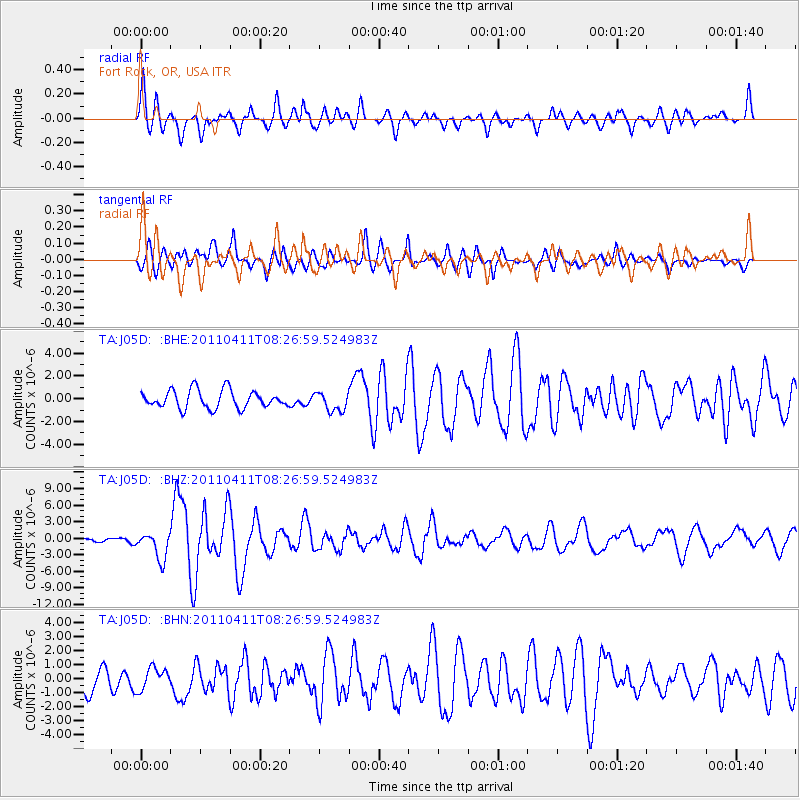
Signal To Noise
| Channel | StoN | STA | LTA |
| TA:J05D: :BHZ:20110411T08:26:59.524983Z | 6.4784846 | 2.465763E-6 | 3.8060796E-7 |
| TA:J05D: :BHN:20110411T08:26:59.524983Z | 1.13082 | 7.8978695E-7 | 6.984197E-7 |
| TA:J05D: :BHE:20110411T08:26:59.524983Z | 1.0694258 | 8.4009207E-7 | 7.855543E-7 |
| Arrivals |
| Ps | 2.6 SECOND |
| PpPs | 9.1 SECOND |
| PsPs/PpSs | 12 SECOND |


