You are here: Home > Network List > TA - USArray Transportable Network (new EarthScope stations) Stations List
> Station W34A Bridge Creek, Tuttle, OK, USA > Earthquake Result Viewer
W34A Bridge Creek, Tuttle, OK, USA - Earthquake Result Viewer
| Earthquake location: |
Eastern Honshu, Japan |
| Earthquake latitude/longitude: |
37.0/140.4 |
| Earthquake time(UTC): |
2011/04/11 (101) 08:16:12 GMT |
| Earthquake Depth: |
11 km |
| Earthquake Magnitude: |
6.4 MB, 6.5 MS, 6.6 MW, 6.6 MW |
| Earthquake Catalog/Contributor: |
WHDF/NEIC |
|
| Network: |
TA USArray Transportable Network (new EarthScope stations) |
| Station: |
W34A Bridge Creek, Tuttle, OK, USA |
| Lat/Lon: |
35.24 N/97.77 W |
| Elevation: |
428 m |
|
| Distance: |
90.1 deg |
| Az: |
44.07 deg |
| Baz: |
317.14 deg |
| Ray Param: |
0.041698687 |
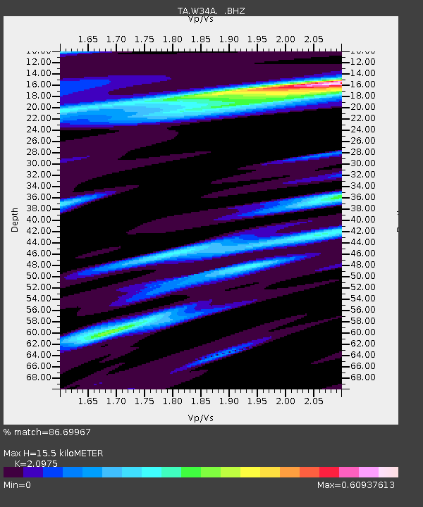
| Estimated Moho Depth: |
15.5 km |
| Estimated Crust Vp/Vs: |
2.10 |
| Assumed Crust Vp: |
6.426 km/s |
| Estimated Crust Vs: |
3.064 km/s |
| Estimated Crust Poisson's Ratio: |
0.35 |
|
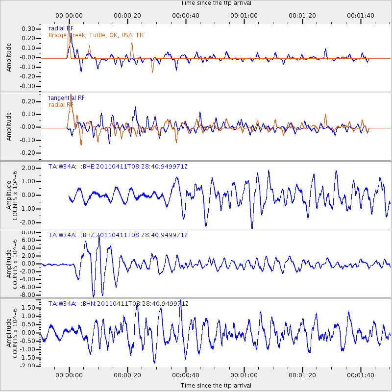
| Radial Match: |
86.69967 % |
| Radial Bump: |
400 |
| Transverse Match: |
91.67565 % |
| Transverse Bump: |
400 |
| SOD ConfigId: |
356183 |
| Insert Time: |
2011-09-27 05:49:50.074 +0000 |
| GWidth: |
2.5 |
| Max Bumps: |
400 |
| Tol: |
0.001 |
|
Signal To Noise
| Channel | StoN | STA | LTA |
| TA:W34A: :BHZ:20110411T08:28:40.949971Z | 12.258722 | 1.7211948E-6 | 1.4040573E-7 |
| TA:W34A: :BHN:20110411T08:28:40.949971Z | 0.79513305 | 2.0947869E-7 | 2.634511E-7 |
| TA:W34A: :BHE:20110411T08:28:40.949971Z | 1.0560472 | 3.453462E-7 | 3.2701777E-7 |
| Arrivals |
| Ps | 2.7 SECOND |
| PpPs | 7.3 SECOND |
| PsPs/PpSs | 10 SECOND |


