You are here: Home > Network List > TA - USArray Transportable Network (new EarthScope stations) Stations List
> Station W32A Sentinel, OK, USA > Earthquake Result Viewer
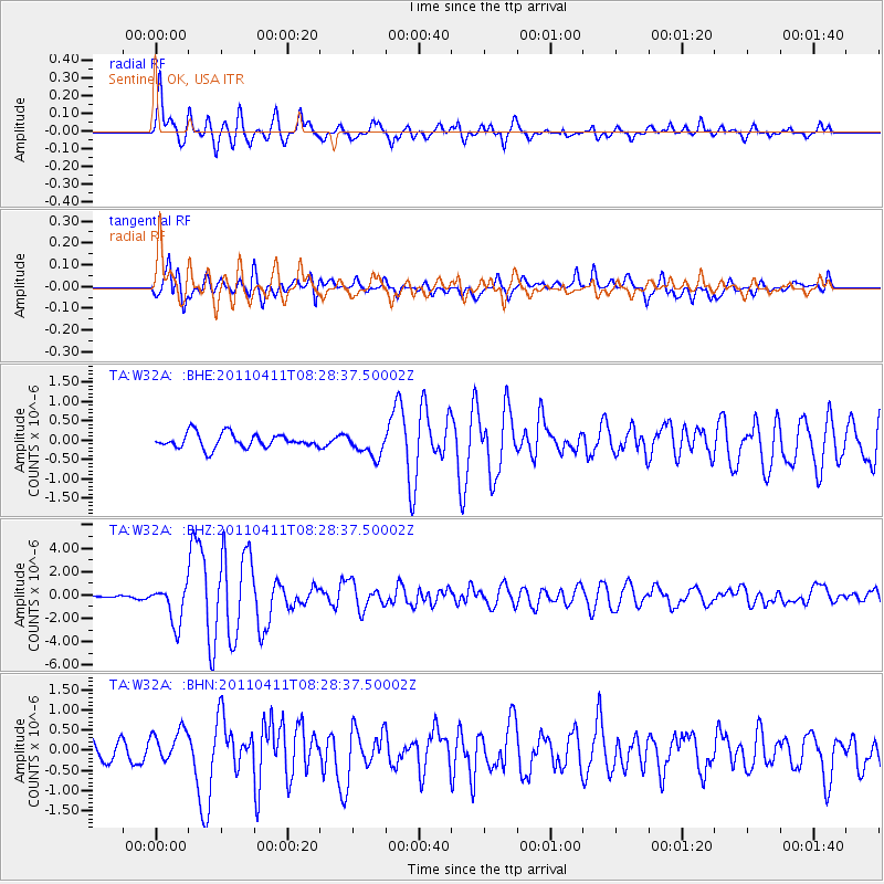
W32A Sentinel, OK, USA - Earthquake Result Viewer
| Earthquake location: |
Eastern Honshu, Japan |
| Earthquake latitude/longitude: |
37.0/140.4 |
| Earthquake time(UTC): |
2011/04/11 (101) 08:16:12 GMT |
| Earthquake Depth: |
11 km |
| Earthquake Magnitude: |
6.4 MB, 6.5 MS, 6.6 MW, 6.6 MW |
| Earthquake Catalog/Contributor: |
WHDF/NEIC |
|
| Network: |
TA USArray Transportable Network (new EarthScope stations) |
| Station: |
W32A Sentinel, OK, USA |
| Lat/Lon: |
35.12 N/99.25 W |
| Elevation: |
494 m |
|
| Distance: |
89.3 deg |
| Az: |
45.024 deg |
| Baz: |
316.301 deg |
| Ray Param: |
0.04192366 |
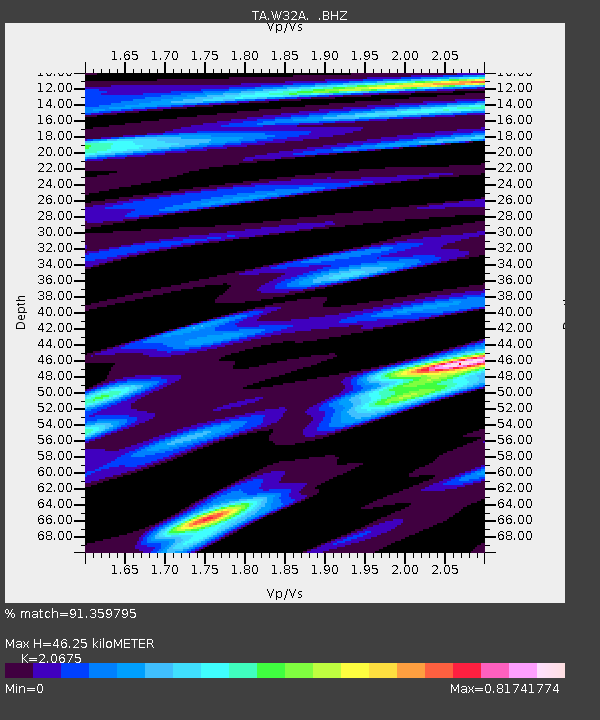
| Estimated Moho Depth: |
46.25 km |
| Estimated Crust Vp/Vs: |
2.07 |
| Assumed Crust Vp: |
6.315 km/s |
| Estimated Crust Vs: |
3.055 km/s |
| Estimated Crust Poisson's Ratio: |
0.35 |
|
| Radial Match: |
91.359795 % |
| Radial Bump: |
400 |
| Transverse Match: |
87.091354 % |
| Transverse Bump: |
400 |
| SOD ConfigId: |
356183 |
| Insert Time: |
2011-09-27 05:50:38.341 +0000 |
| GWidth: |
2.5 |
| Max Bumps: |
400 |
| Tol: |
0.001 |
|
Signal To Noise
| Channel | StoN | STA | LTA |
| TA:W32A: :BHZ:20110411T08:28:37.50002Z | 11.797899 | 1.6416463E-6 | 1.3914735E-7 |
| TA:W32A: :BHN:20110411T08:28:37.50002Z | 1.7020268 | 4.0972424E-7 | 2.4072725E-7 |
| TA:W32A: :BHE:20110411T08:28:37.50002Z | 1.6381997 | 3.040041E-7 | 1.8557205E-7 |
| Arrivals |
| Ps | 8.0 SECOND |
| PpPs | 22 SECOND |
| PsPs/PpSs | 30 SECOND |


